Press release
Rare 1811 Linen Printed Louisiana Territory Map Highlights New Acquisitions at Boston Rare Maps

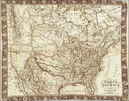
"North America from the most Authentic and Latest Surveys" by R. Gray. Published Glasgow, 1811. Engraving in sepia ink on linen,
Highlighting this selection of new acquisitions is a rare map of North America, printed on linen by mapmaker R. Gray. Gray’s 1811 map is based on Robert Wilkinson’s important, unusual and rare North America, which was first published in London in 1804. Wilkinson’s was the first printed map to show the entire Louisiana Territory incorporated into the United States and also depicted the short-lived state of “Franklin” between North Carolina and Tennessee. Gray followed Wilkinson’s work closely, though he simplified the toponymy to allow for the limitations of printing on fabric. He also added an ornate decorative border to the piece, rendering the map far more attractive than the prototype. Gray’s map is surpassingly rare, and this is only the third known example.
Also on offer is a “Map of the Present Seat of War on the Borders of Canada,” depicting a region encompassing Lake George, Lake Champlain and the upper St. Lawrence River. The map illustrates the fastest and only water-based link between Quebec and the interior of the thirteen American colonies, a route prized for its strategic import.
It originally appeared in October 1775 issue of The Pennsylvania Magazine, the sole periodical published in America during the Revolution. Several issues of the magazine included engraved maps illustrating early Revolutionary battles and theatres of conflict, and this map printed by Robert Aitken is one of the rarest and most appealing.
An 1889 chart of America’s west coast is also featured. This manuscript by New Hampshire native John Tilton McClintock depicts the northwest coast from the Alaska panhandle to Tillamook County, Oregon. The son of an expert surveyor and himself a future architect, McClintock—in his late teens at the time—was already an accomplished draftsman. His map shows the complex coastal outline and the region’s many islands, indicates the many mountains and mountain ranges, names major geographical features and towns, and outlines county boundaries in Oregon and Washington. The intent of the map appears to have been to illustrate or memorialize a round-trip journey from Puget Sound to Glacier Bay for the benefit of friends or family back home. The voyage track is shown in red ink, with a few July dates indicated in Alaska, apparently the dates of landfall at different ports of call.
"I'm delighted to bring this latest selection of material to market," comments Michael Buehler, owner of Boston Rare Maps. "Our goal is to identify and make available some of the most rare, interesting and historically significant American maps and prints, and these fine examples meet that standard."
A number of additional maps are also featured in Boston Rare Maps latest acquisitions and are available for view at www.BostonRareMaps.com. Boston Rare Maps will also participate in the upcoming Miami International Map Fair, which features over 40 premier map dealers from around the world and takes place February 2-3, 2013.
Editor’s Note: • Background and additional digital color images available.
• Support for feature development on rare maps available.
• Interviews with gallery owner Michael Buehler are encouraged.
About Boston Rare Maps
Boston Rare Maps specializes in rare and unusual antique and vintage maps depicting all periods of American history. They offer American historical prints, city views and a growing selection of illustrated broadsides. They also serve a wide variety of clients, including private collectors and institutional map collections, as well as those seeking just a few special pieces for themselves or as gifts to clients, friends or family.
Jenna Llewellyn
(617) 363-0405
info@fuscofour.com
8 Allenwood Street
Boston, MA 02132
This release was published on openPR.
Permanent link to this press release:
Copy
Please set a link in the press area of your homepage to this press release on openPR. openPR disclaims liability for any content contained in this release.
You can edit or delete your press release Rare 1811 Linen Printed Louisiana Territory Map Highlights New Acquisitions at Boston Rare Maps here
News-ID: 248947 • Views: …
More Releases from Boston Rare Maps

Boston Rare Maps Showcases First Antique Map of The Independent United States at …
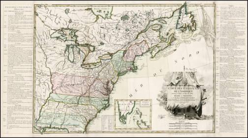
MIAMI, FL – Boston Rare Maps, one of the country’s premier specialists in rare and unusual antique maps, announces the acquisition of an important and highly sought-after 1784 map by Jean Lattré, noted as the first map of the independent United States. The map, a rare variant including text panels describing the “principal events” of the American Revolution, will highlight Boston Rare Maps’ offerings at this year’s Miami International…

Boston Rare Maps Features Civil War Maps and Ephemera
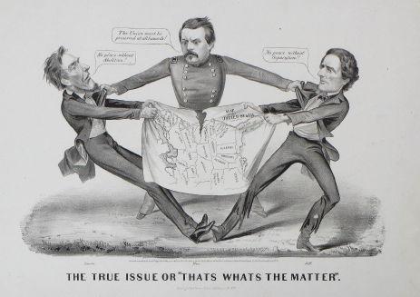
SOUTHAMPTON, MA – Boston Rare Maps, one of the country’s premier specialists in rare and unusual antique maps, presents a unique selection of original maps and ephemera from the American Civil War. Included is an iconic 1864 Currier & Ives political cartoon, a schematic map detailing the battle of Gettysburg and a handwritten report by a South Carolina general assessing the tactical situation in Charleston Harbor before the bombardment…
More Releases for America
Stabilit America Highlights Applications of Fiberglass Roof Panels with Stabilit …
Roofing materials are very important in the realm of modern construction, as they should be long lasting, economical and attractive. Fiberglass roof panels are a few of the numerous choices among several alternatives that have received a reputation of being versatile, long life, and adaptable in various sectors. They are favored by the architects, contractors, and property developers due to their lightweight construction, resistance to weather factors, and the ease…
Deodorants Market Report by Region (North America, EMEA, Latin America, Asia)
2025 - Pristine Market Insights, a leading market research firm, announced the release of its latest and comprehensive market research report on Deodorants market. The report spans over 500 pages and delivers 10-year market forecast in US dollars (or custom currencies upon request). It provides in-depth analysis of market dynamics (drivers, opportunities, restraints), PESTLE insights, latest industry trends, and demand factors. The report includes segmented market value, share (%), compound…
Sequestrant Market Report by Region (North America, EMEA, Latin America, Asia)
2025 - Pristine Market Insights, a leading market research firm, announced the release of its latest and comprehensive market research report on Sequestrant market. The report spans over 500 pages and delivers 10-year market forecast in US dollars (or custom currencies upon request). It provides in-depth analysis of market dynamics (drivers, opportunities, restraints), PESTLE insights, latest industry trends, and demand factors. The report includes segmented market value, share (%), compound…
Buttermilk Market Study by Region (North America, Latin America, Europe, Asia, M …
2025 - Pristine Market Insights, a leading market research firm, announced the release of its latest and comprehensive market research report on Buttermilk market. The report spans over 500 pages and delivers 10-year market forecast in US dollars (or custom currencies upon request). It provides in-depth analysis of market dynamics (drivers, opportunities, restraints), PESTLE insights, latest industry trends, and demand factors. The report includes segmented market value, share (%),…
Textiles Market Analysis Report, Regional Outlook - Europe, North America, South …
Adroit Market Research has announced the addition of the “Global Textiles Market Size Status and Forecast 2025”, The report classifies the global Textiles in a precise manner to offer detailed insights about the aspects responsible for augmenting as well as restraining market growth.
This report studies the global Textiles Speaker market, analyzes and researches the Textiles Speaker development status and forecast in Europe, North America, Central America, South America, Asia Pacific…
Global Gaucher Disease Market 2018 Covering North America, South America, Europe
Gaucher Disease Market
Summary
The Global Gaucher Disease Market is defined by the presence of some of the leading competitors operating in the market, including the well-established players and new entrants, and the suppliers, vendors, and distributors. The key players are continuously focusing on expanding their geographic reach and broadening their customer base, in order to expand their product portfolio and come up with new advancements.
Gaucher Disease market size to maintain the average annual growth…