Press release
Boston Rare Maps Showcases First Antique Map of The Independent United States at Miami Map Fair, Feb. 4-5, 2012
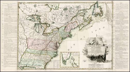
MIAMI, FL – Boston Rare Maps, one of the country’s premier specialists in rare and unusual antique maps, announces the acquisition of an important and highly sought-after 1784 map by Jean Lattré, noted as the first map of the independent United States. The map, a rare variant including text panels describing the “principal events” of the American Revolution, will highlight Boston Rare Maps’ offerings at this year’s Miami International Map Fair, taking place February 4-5, 2012. For additional information, please visit www.BostonRareMaps.com or call (413) 527-4020.This famous map, which appeared in June 1784, is the first of the independent United States. It was printed just a few months after the country gained official independence through the final ratification of the Treaty of Paris by the United States in February 1784 and Great Britain in April of the same year.
Flanking the map are panels of text giving a year-by-year, colony-by-colony account of the American Revolution. These panels were printed on separate sheets and were pasted to the map’s left and right-hand margins, but few surviving impressions are known with the text intact. Only four copies with the complete original text have been identified: one at the Library of Congress, another at the Library of the Society of the Cincinnati, one in a private American collection, and this example. The map was separately issued and is rare in any condition, making this beautiful specimen a coveted addition to any collection.
The exquisite cartouche contains the title as well as the dedication to Franklin, superimposed upon the foresail of what appears to be a Ship of State. A seaman hangs emblems of the new United States along the fore topsail, including the Great Seal and the insignia of the Order of the Cincinnati.
In addition to this extraordinary piece, Boston Rare Maps will also present a host of additional rare and unusual antique maps. Included in the selection will be the first printed map of Washington, D.C.; a rare 18th-century plan of New York City; and a broadside commemorating the completion of the Atlantic Telegraph. Additional antique maps and historic broadsides are available to view at www.BostonRareMaps.com.
Editor’s Note: • Background and additional digital color images available.
• Support for feature development on rare maps available.
• Interviews with gallery owner Michael Buehler are encouraged.
About Boston Rare Maps
Boston Rare Maps specializes in rare and unusual vintage and antique maps depicting all periods of American history. They offer American historical prints, city views and a growing selection of illustrated broadsides. They also serve a wide variety of clients, including private collectors and institutional map collections, as well as those seeking just a few special pieces for themselves or as gifts to clients, friends or family.
Joshua Payne
617-363-0405
info@fuscofour.com
8 Allenwood Street
Boston, MA 02132
This release was published on openPR.
Permanent link to this press release:
Copy
Please set a link in the press area of your homepage to this press release on openPR. openPR disclaims liability for any content contained in this release.
You can edit or delete your press release Boston Rare Maps Showcases First Antique Map of The Independent United States at Miami Map Fair, Feb. 4-5, 2012 here
News-ID: 207760 • Views: …
More Releases from Boston Rare Maps

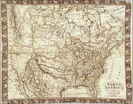
Rare 1811 Linen Printed Louisiana Territory Map Highlights New Acquisitions at B …
SOUTHAMPTON, MA – Boston Rare Maps, one of the country’s premier specialists in rare and unusual antique maps, announces the acquisition of a number of exciting new pieces, among them a rare linen-printed 1811 map that depicts the short-lived state of “Franklin.” Additional works include a charming map of Lake Champlain printed in America during the Revolutionary War, the first-ever printed chart of Boston Harbor, and a mammoth hand-drawn…

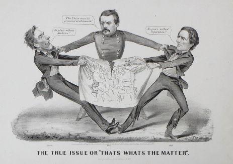
Boston Rare Maps Features Civil War Maps and Ephemera
SOUTHAMPTON, MA – Boston Rare Maps, one of the country’s premier specialists in rare and unusual antique maps, presents a unique selection of original maps and ephemera from the American Civil War. Included is an iconic 1864 Currier & Ives political cartoon, a schematic map detailing the battle of Gettysburg and a handwritten report by a South Carolina general assessing the tactical situation in Charleston Harbor before the bombardment…
More Releases for Map
Map It Media, Putting Businesses On The Map
Image: https://www.getnews.info/wp-content/uploads/2024/08/1724359984.png
Map It Media: Your Go-To Full-Service Business Solution
In today's fast-paced digital landscape, businesses of all sizes are constantly seeking ways to enhance their online presence and streamline operations. Enter Map It Media, a full-service business solution that caters to the needs of both small businesses and large enterprises alike. With a mission to "put you on the map," Map It Media offers a comprehensive suite of services designed to…
Digital Map Market Still Has Room to Grow | Emerging Players Google, Digital Map …
Global Digital Map Market Report from AMA Research highlights deep analysis on market characteristics, sizing, estimates and growth by segmentation, regional breakdowns & country along with competitive landscape, player's market shares, and strategies that are key in the market. The exploration provides a 360° view and insights, highlighting major outcomes of the industry. These insights help the business decision-makers to formulate better business plans and make informed decisions to improved…
Digital Map Market Revenue, Facts, Statastics By DigitalGlobe, Digital Map Produ …
Digital Map Market research report is a resource that makes available current as well as upcoming technical and financial details of the industry. The report not only takes into consideration all the market drivers and restraints which are derived from SWOT analysis but also gives all the CAGR projections for the historic year 2018, base year 2019 and forecast period. This industry analysis report speaks in detail about the manufacturing process,…
Digital Map Market 2019 Precise Outlook –Magellan, Yahoo, Automotive Navigatio …
The Digital Map Market report is a compilation of first-hand information, qualitative and quantitative assessment by industry analysts, inputs from industry experts and industry participants across the value chain. The report provides in-depth analysis of parent market trends, macro-economic indicators and governing factors along with market attractiveness as per segments. The report also maps the qualitative impact of various market factors on market segments and geographies.
Get Sample Copy of this…
Digital Map Market : A Well-Defined Technological Growth Map With An Impact Anal …
GLOBAL DIGITAL MAP MARKET SIZE, STATUS AND FORECAST 2020-2026
The report provides a unique tool for evaluating the Digital Map Market, highlighting opportunities, and supporting strategic and tactical decision-making. This report recognizes that in this rapidly-evolving and competitive environment, up-to-date marketing information is essential to monitor performance and make critical decisions for growth and profitability. It provides information on trends to identify emerging technologies and developments, and focuses on markets capacities…
Digital Map Market Outlook to 2027 - ESRI, TOMTOM, Google, Mapbox, Digital Map P …
An off-the-shelf report on Digital Map Market which has been compiled after an in-depth analysis of the market trends prevailing across five geographies (North America, Europe, Asia-Pacific, Middle-East and Africa, and South America). Various segments of the market such as type/components/ application/industry verticals/ end-users are analyzed with robust research methodology which includes three step process starting with extensive secondary research to gather data from company profiles, global/regional associations, trade journals,…
