Press release
Production Of High Quality 3D City Models Within A Few Days
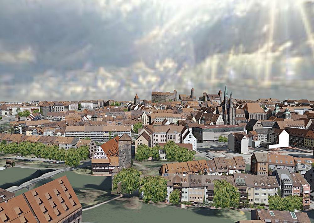
Nuernberg 3D city model
Customers can use their stereo aerial images, their satellite images or LIDAR (only if available) data as input and GTA GeoService GmbH will use photogrammetric technology to provide GIS ready and textured (or colored) 3D city models. Buildings can be delivered in all common data formats such as CityGML, 3D Shape or DXF. Thus GTA's customers can use their own GIS or CAD software to work with the models or to even enhance them further.
GTA Geoservice GmbH aims at being a white label partner to established GIS or remote sensing companies that would like to extend their services or simply need a boost in efficiency and/or capacity. By utilizing the highly developed tridicon® software suite within a setting of 20 years of experience, GTA can help to achieve a real competitive advantage in the growing market of 3D GIS. tridicon® is considered to be the most efficient and most automized solution available at this time.
GTA Geoservice GmbH is a recent offspin of the German GTA Geoinformatik GmbH, the developers of tridicon® software solutions. As the former service department of GTA Geoinformatik GmbH, they possess many years of experience in large photogrammetric projects of any kind as well as GIS.
GTA GeoService GmbH
Lindenstrasse 63
D-17033 Neubrandenburg
Germany
http://www.gta-geoservice.de
info@gta-geoservice.de
Phone: +49 395 3581 179
Fax: +49 395 3684 424
Marketing contact: Kathrin Hutton
hutton@gta-geoservice.de, Tel +49 395 3581 238
This release was published on openPR.
Permanent link to this press release:
Copy
Please set a link in the press area of your homepage to this press release on openPR. openPR disclaims liability for any content contained in this release.
You can edit or delete your press release Production Of High Quality 3D City Models Within A Few Days here
News-ID: 241889 • Views: …
More Releases from GTA GeoService GmbH
Many Brandenburg Cities Already Available in 3D
The production of 3D building models for the Brandenburg Surveying and Geoinformation Authority is completed.
Digital 3D city models are more and more being used for urban planning, solar potential assessment, noise and emission prognoses, mobile communications planning, heat requirement maps, tourism and marketing as well as many other applications.
The Brandenburg Surveying and Geoinformation Authority (Landesbetrieb Landesvermessung und Geoinformation Brandenburg, LGB) assigned M.O.S.S. Computer Grafik Systeme GmbH…
More Releases for GIS
Geographic Information System (GIS) Software Global Market Report 2024 - Geograp …
"The Business Research Company recently released a comprehensive report on the Global Geographic Information System (GIS) Software Market Size and Trends Analysis with Forecast 2024-2033. This latest market research report offers a wealth of valuable insights and data, including global market size, regional shares, and competitor market share. Additionally, it covers current trends, future opportunities, and essential data for success in the industry.
According to The Business Research Company's, The…
Asset Management GIS World 2024 Coverage
Several public works organizations have made a significant investment into gaining and deploying a geospatial information system (GIS) for tracking their spatial assets, maintaining historical records and sustaining a precise inventory. GIS data delivers invaluable information to these asset management organizations. Whether the user organizations have utilities, roads, parks and recreation, bridges, signals or facilities, a robust integration between asset management and GIS is integral to a long term, successful…
Integration of BIM & GIS
Building information modeling (BIM) and geographic information systems (GIS) are two technologies that have particular applications. GIS has mapping characteristics and geographical databases, while BIM is primarily utilized for building assets as an object-based information model. In challenging and extensive projects, the connecting thread between these two technologies is gaining legitimacy. BIM technologies are typically used in projects related to architecture and civil engineering, while GIS systems are typically used…
Mobile GIS Market is Anticipated to Gain Moderate CAGR by 2027 | ESRI, GIS Cloud
Mobile GIS market research analysis depicts severe economic consequences caused due to the outbreak COVID-19, which affected the entire society and world economy. Present and previous pricing structure made here helps industry players to bring the right products into the market and gain huge returns. Newly entering market player needs to take the help of this Mobile GIS market research when launching any new product. A few of the vital…
GIS Software Market 2025 by Component, Type of GIS Software, Functions, Organiza …
Increasing adoption of GIS for facilities management, integration of GIS with mainstream technologies for business intelligence, and growing demand for GIS software for smart cities development as well as urban planning have fueled the growth of the global GIS Software Market.
For Purchase Inquiry: https://www.alliedmarketresearch.com/purchase-enquiry/5259
The global GIS software market was valued at $3.24 billion in 2017 and is expected to hit $7.86 billion in 2025, registering a CAGR of 11.8% from…
Global Cloud GIS Sales Market Top player: CartoDB , ESRI , Hexagon, GIS Cloud
The report offers a comprehensive evaluation of the market. It does so via in-depth insights, understanding market evolution by tracking historical developments, and analyzing the present scenario and future projections based on optimistic and likely scenarios. Each research report serves as a repository of analysis and information for every facet of the market, including but not limited to: Regional markets, technology developments, types, applications, and the competitive landscape.
Browse Complete…
