Press release
Tested in mass production and now new on the market: software for automatic production of 3D city models
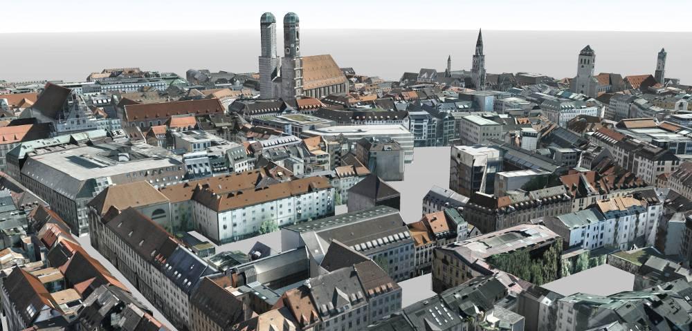
3D city model Munich, LOD 2, photorealistic textures
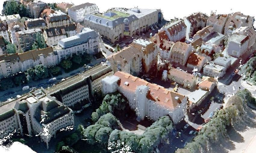
tridicon 3D delivers high quality models from stereo aerial imagery. Other suitable data sources are LiDAR data (airborne laserscanning) and stereo satellite imagery. Furthermore a digital terrain model and building footprints are used.
Depending on the type of source data and the targeted quality of the results different software suites are on offer. Applications like visualisation, quality control and editing of the produced data are intergrated. Optionally, tridiconTM 3D offers fully automatic texturing from aerial images as well as the analysis of the solar potential. The tridicon CITY DISCOVERER as an additional module is available for versatile visualisation and analysis of 3D city models. Dynamic loading of terrain and buildings allows the realtime visualisation of 3D city models of any size. In cooperation with the Fraunhofer Institute for Computer Graphics (IGD) GTA markets CityServer3D as a database solution for the management and updating of 3D city models. One of the first customers of the complete software suite is the German „Landesamt für innere Verwaltung MV“ in Schwerin, which will produce 3D buildings for the federal state of Mecklenburg-Vorpommern country-wide.
3D buildings generated with tridicon 3D can be exported in all common data formats (CityGML, 3D Shape, KML, OBJ, 3DS, VRML).
tridicon 3D enables commercial and municipal users to produce high quality 3D city models in LOD 2 quickly, area-wide and cost-effectively.
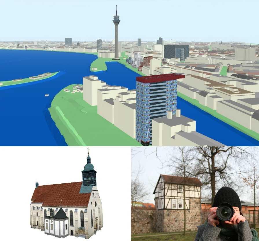
For the professional production of digital 3D landmarks GTA offers the software suite tridicon 3D LANDMARK.
Customers with an update contract can look forward to planned enhancements. Modules for the automatic modelling of buildings from aerial imagery without footprints as well as the automatic recognition of façades will be released in 2011.
The company - GTA Geoinformatik GmbH
GTA, - founded in 1991 as geoinformatics company with its main office in Neubrandenburg, is one of the leading producers in 3D production technology worldwide and has 50 employees.
GTA Geoinformatik GmbH has already compiled more than ten million buildings and produced more than 200 digital 3D city maps for European, North American and Asian capitals and major cities. Since the starting of 3D business, GTA has also produced more than 4.800 digital 3D landmarks.
GTA Geoinformatik GmbH
Managing director: Dr. Peter Lieckfeldt
Lindenstraße 63, D-17033 Neubrandenburg
Tel.: +49 395 35 81 142
Fax: +49 395 36 84 424
Email: contact@tridicon.de
Internet: www.tridicon.de
Marketing contact: Kathrin Hutton
hutton@gta-geo.de, Tel. +49 395 3581 238
This release was published on openPR.
Permanent link to this press release:
Copy
Please set a link in the press area of your homepage to this press release on openPR. openPR disclaims liability for any content contained in this release.
You can edit or delete your press release Tested in mass production and now new on the market: software for automatic production of 3D city models here
News-ID: 158106 • Views: …
More Releases from GTA Geoinformatik GmbH
New Software Solution for Automatic Point Cloud Generation and 3D Modelling from …
GTA Geoinformatik GmbH presents new 3D software solutions at COM.GEO 2012 in Washington D.C.
Fully automated generation of very dense 3D point clouds and Digital Surface Models (DSM) from stereo aerial images (nadir and oblique) seems to become more and more important. Most efficiently this is done using semi global matching (SGM) algorithms. With the software release tridicon® PointCloud GTA offers a new tool that produces accurate point clouds for…

Breakthrough in Automatic Analysis of Aerial Images with Computer Stereo Vision
GTA Geoinformatik GmbH presents revolutionary new technology for automatic 3D object reconstruction without help of any 2D map data at CeBIT 2012
At this years CeBIT in Hannover dated 06th to 10th March GTA for the first time presents a prototype of a new tridicon® software version, that enables the detection of 3D objects like buildings without the need for 2D vector data (e. g. building outlines). The only source…
New Possibilities in Digitizing Aerial Images - Enhance Safety and Usability of …
Most larger municipalities or government agencies as well as many privately owned companies from the geodata sector own a large archive of aerial imagery on film. These archives contain a value of many ten thousands of dollars which is hardly used or recognized. Today's scanning technology together with up to date software tools and data storage systems make possible a much higher scanning resolution than only few years ago. Where…
High-Quality 3D Modelling Using Georeferenced Photography
Production of georeferenced digital 3D landmarks from terrestrial photography using the software suite tridicon® 3D LANDMARK
Digital 3D city models become very popular. Internet maps and car navigation are much more user-friendly when using 3D visualisation. Many municipalities use 3D city models for applications in town and environmental planning, for noise control management, for solar panel assessments or for marketing purposes. New technologies like 3D printing allow the fast and cost-efficient…
More Releases for LOD
Outsourcing Scan to BIM Services to India: A Strategic Advantage for AEC Firms
In the ever-evolving Architecture, Engineering, and Construction (AEC) industry, Scan to BIM (Building Information Modeling) has emerged as a powerful tool to bridge the gap between the physical and digital worlds. The process involves capturing existing building or site conditions using 3D laser scanning (LiDAR), then converting the point cloud data into intelligent BIM models. These models enable accurate design, planning, renovation, and facility management workflows.
As global demand for Scan…
CAD to BIM Services: Bridging Traditional Drafting with Modern Digital Construct …
In the evolving world of architecture, engineering, and construction (AEC), the shift from CAD (Computer-Aided Design) to BIM (Building Information Modeling) represents a major transformation. While CAD focuses on creating 2D/3D drawings, BIM enables a data-rich, collaborative modeling environment where every component of a building carries intelligent information.
CAD to BIM services help companies migrate their legacy 2D drawings or simple 3D CAD models into detailed, structured BIM models-improving coordination, accuracy,…
LOD Properties Expands Into All Michigan Markets Enabling Homeowners To Sell The …
Image: https://www.getnews.info/wp-content/uploads/2024/10/1727919223.png
LOD Properties announces an expansion into all Michigan markets. LOD Properties has provided access to quick and easy home sales throughout neighboring markets and due to customer demand expanded quickly into all major markets in the region. Furthermore, LOD Properties has introduced a helpful service that allows homeowners to sell their properties for cash before relocating. Homeowners in the area who want cash for their home can receive a…
Global Shea Butter Market: Market Size & Forecast, Market Share, Industry Trends …
xResearch announces the launch of a market research report titled “Global Shea Butter Market 2018-2023”. The research reports provide a comprehensive and extensive overview of the marketplace including information on the Shea Butter market size and Shea Butter market share. The Shea Butter industry report can help you gain further insight into the Shea Butter market trends and gain valuable Shea Butter data.
According to the report, the global Shea Butter…
Pix4Dmapper 3.2 Now Generates Tiled Level-of-Detail (LoD) Mesh
Today, we are happy to announce our Pix4Dmapper Desktop 3.2 release. The new version has great advancement in stability and usability - Upload desktop projects to cloud is now 10x faster; Camera parameter correlations are displayed in the quality report for easier troubleshooting and assessment; New key output: tiled level-of-detail mesh is available in osgb and Esri formats; and the software is now available in Russian Language.
Tiled LoD Mesh…
GTA offers special rates for tridicon® 3D software solution
Software for the automatic generation of 3D city models available at very competitive prices
GTA Geoinformatik GmbH will present its full range of new pathbreaking software solutions for automatic creation and utilization of 3D city models at Nuremberg from the 27th to the 29th of September 2011 (Hall 7A, booth G45).
tridicon® 3D software automatically generates high-quality 3D buildings in LOD 2 from LiDAR point clouds, stereo aerial or satellite imagery.
The…
