Press release
Aerial Survey Flight for Mexico City Cadaster

Cadaster Mexcio Aerial Survey Photography Ultracam IMU
The flight was executed with a Microsoft/Vexcel large format UltraCam digital aerial camera using IMU and airborne DGPS. A total of more than 9,000 images were taken also on Christmas Day. The postprocess of all images was done in the offices of GeoAir. All raw data were processed to level 3, 8 bit and RGB/Infrared 16 bit. A total of more than 12 terabyte of digital imaging data was processed.
Mexico City is the busiest airport in whole Latin America. Therefore the coordination with air traffic control was essential especially crossing all approach and departure routes at some 4,000 ft AGL.
GeoAir logró en solo 4 semanas volar todo el catastro de México DF. El vuelo de medición se realizó con una cámara digital de formato grande del tipo Microsoft/Vexcel UltraCam, incluyendo el uso de una IMU y AGPS. La resolución fue 9 cm GSD en la mayor parte y 16 cm GSD en la parte sur hacia la sierra. En total se tomaron más de 9,000 imágenes de alta calidad.
GeoAir también hizo el postproceso de todos los datos digitales desde los datos crudos hasta nivel 3 con 16 bit rgb / infrarrojo color. Un total de más de 12 Terabytes fueron tomados y postprocesados.
El aeropuerto de la Ciudad de México es el más frecuentado en toda Latinoamérica. La coordinación con el control del tráfico aéreo fue primordial sobre todo porque se tuvo que cruzar todas las aproximaciones y salidas en solo 4,000 piés sobre el terreno.
In nur 4 Wochen gelang es GeoAir Internacional den Bildflug für das Kataster in Mexico City fertigzustellen. Der Messflug wurde mit einer digitalen Microsoft/Vexcel Luftbild Kamera UltraCam durchgeführt, einschließlich IMU und DGPS zur Bestimmung der Orientierungs- Parameter der Aufnahmen.
Die GSD war 9 cm im Stadtbereich und 16 cm im südlichen Agglomerationsbereich.
Insgesamt wurden mehr als 9,000 digitale Bilder aufgenommen. Der Postprozess der digitalen Bilddaten wurde auch bei GeoAir durchgeführt und zwar zum einen 8 bit RGB und zum anderen 16 bit RGB / Infrarot. Insgesamt wurden 12 Terabyte erfaßt und prozessiert.
Mexico City hat in ganz Lateinamerika die größte Verkehrsdichte und deshalb war die Koordination mit den Fluglotsen besonders wichtig. Zumal die Flugstreifen in 4,000 ft über Grund sämtliche Anflug- und Abflugsektoren kreuzten.
Although the foundation of GeoAir S.A. de C.V. took only place in 1995 we have been flying successfully thousands of square kilometers in 30 countries with all different kinds of films. Among other companies we have been flying for such renowned companies like Hansa Luftbild of Germany, Swissphoto of Switzerland, Orthoshop, GeoMapa, Cartodata, SAP and Horizons in Mexico, ISTAR of France, GeoSurv, Eaglemapping and DTM of Canada, Geocart, Stereocarto and Azimut in Spain, the United Nations and many other institutions and ministries.
GeoAir Internacional S.A. de C.V.
Avenida Alfanjes 1
Izcalli Acatitlán
Tlalnepantla
Estado de México
C.P. 54140 / MÈXICO
Tel: +52-777-361-3875
Email: info @geoair.net
Email: info @geoair-internacional.com
homepage: www.geoair-internacional.com
This release was published on openPR.
Permanent link to this press release:
Copy
Please set a link in the press area of your homepage to this press release on openPR. openPR disclaims liability for any content contained in this release.
You can edit or delete your press release Aerial Survey Flight for Mexico City Cadaster here
News-ID: 64260 • Views: …
More Releases from GeoAir Internacional
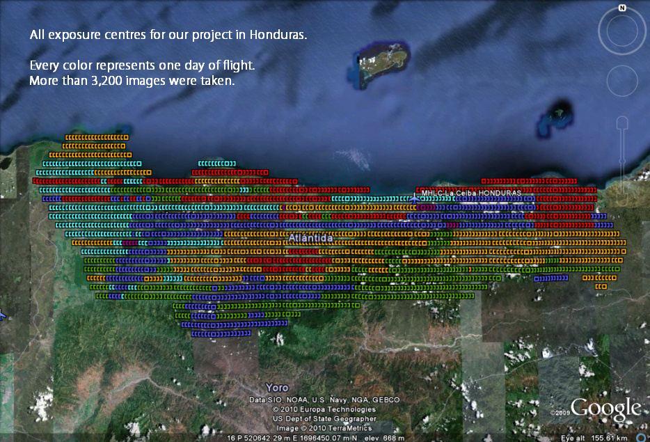
Honduras Aerial Surveys
GeoAir delivers complete digital aerial imagery for the cadastre in the state of Cortés in Honduras
The project called Catastro de Cortés is a free public service provided by the Instituto de la Propiedad (IP) through the Programa de Administración de Tierras de Honduras (PATH). It deals mainly with cartographic activities and cadastral information of 5 municipalities in the state of Cortés: San Pedro Sula, Puerto Cortés, Choloma, Villanueva, and…
More Releases for IMU
IMU Inertial System Market Size 2024 to 2031.
Market Overview and Report Coverage
A key component in various industries, an Inertial Measurement Unit (IMU) is an electronic device that measures and reports a craft's velocity, orientation, and gravitational forces. The IMU Inertial System Market is poised for robust growth, with a forecasted CAGR of 11.20% during the projected period.
Factors driving this growth include the increasing adoption of IMUs in aerospace and defense applications for navigation, guidance,…
High-Performance Imu Market Growth Opportunities: Insights from Latest Research …
"Global High-Performance Imu Market Overview:
Global High-Performance Imu Market Report 2022 comes with the extensive industry analysis by Introspective Market Research with development components, patterns, flows and sizes. The report also calculates present and past market values to forecast potential market management through the forecast period between 2022-2028.This research study of High-Performance Imu involved the extensive usage of both primary and secondary data sources. This includes the study of various parameters…
How Electronic Imu Sensors Market Development is Changing Business Needs?
Electronic Imu Sensors Market Study 2023-2029:
Electronic Imu Sensors Market (Newly published report) which covers Market Overview, Future Economic Impact, Competition by Manufacturers, Supply (Production), and Consumption Analysis, and focuses on various products and other market trends.
The market research report on the global Electronic Imu Sensors industry provides a comprehensive study of the various techniques and materials used in the production of Electronic Imu Sensors market products. Starting from industry chain…
Electronic IMU Sensors Market Size, Share, Development by 2023
An inertial measurement unit (IMU) sensor is an electronic device that measures and reports a craft's velocity, orientation, and gravitational forces, using a combination of accelerometers and gyroscopes, sometimes also magnetometers. In this report, the high performance IMU sensors were counted and analyzed. We take into account industrial, aerospace, defense applications (even industrial applications are considered as "high-performance" applications, as opposed to consumer ones). This refers to the applications: we…
Inertial Measurement Unit (IMU) Sensors Market 2021 | Detailed Report
Inertial Measurement Unit (IMU) Sensors Market Forecasts report provided to identify significant trends, drivers, influence factors in global and regions, agreements, new product launches and acquisitions, Analysis, market drivers, opportunities and challenges, risks in the market, cost and forecasts to 2027.
Get Free Sample PDF (including full TOC, Tables and Figures) of Inertial Measurement Unit (IMU) Sensors Market @ https://www.reportsnreports.com/contacts/requestsample.aspx?name=5048490
The report provides a comprehensive analysis of company profiles listed below:
-…
Inertial Measurement Unit (IMU) Market Growth And Share Analysis By 2027
Los Angeles, United States,: This research study is one of the most detailed and accurate ones that solely focus on the global Inertial Measurement Unit (IMU) market. It sheds light on critical factors that impact the growth of the global Inertial Measurement Unit (IMU) market on several fronts. Market participants can use the report to gain a sound understanding of the competitive landscape and strategies adopted by leading players of…
