Press release
Geospatial Analytics Market Expected to Witness Strong Growth Through 2033, Led by North America's 35.9% Market Share

Geospatial Analytics Market
Get a Sample PDF Of This Report (Get Higher Priority for Corporate Email ID):- https://www.datamintelligence.com/download-sample/geospatial-analytics-market?ram
The Global Geospatial Analytics Market size is projected to reach with a CAGR of 12.8% over the forecast period 2026-2033.
The market is experiencing substantial growth due to the increasing adoption of location-based technologies across urban planning, transportation, agriculture, defense, and environmental monitoring sectors. Rising investments in smart city initiatives, satellite imaging, GIS platforms, and real-time spatial data analysis are further driving demand for advanced geospatial analytics solutions worldwide.
Industry participants are focusing on integrating artificial intelligence, cloud computing, and IoT-enabled geospatial systems to improve predictive analytics, operational efficiency, and decision-making capabilities. Growing demand for precision mapping, disaster management, asset tracking, and infrastructure monitoring is expected to create long-term opportunities for technology providers, software developers, and analytics service companies throughout the forecast period.
Key Industry Developments
United States:
✅ April 2026: Niantic Spatial introduced Scaniverse and VPS 2.0, enabling AI-powered "machine-readable" spatial mapping with centimeter-level positioning accuracy. The advancement strengthened real-time geospatial analytics capabilities for robotics, logistics, AR applications, and digital twin environments through large-scale 3D spatial reconstruction technology.
✅ February 2026: Esri enhanced ArcGIS Online with AI-driven metadata and spatial data management tools designed to improve discoverability and automation in enterprise GIS workflows. The update focused on generative AI integration for geospatial analytics, helping organizations accelerate digital twin, infrastructure, and environmental monitoring projects.
✅ January 2026: Esri released major updates to ArcGIS Earth Desktop and ArcGIS Pro 3.6, including Historical Imagery Explorer and advanced spatial analysis capabilities. The launch improved 3D geospatial visualization, temporal mapping analysis, and real-time decision-making for urban planning, defense, and disaster resilience initiatives.
Japan:
✅ December 2025: Geospatial Information Authority of Japan expanded national high-resolution 3D mapping and digital terrain modeling initiatives to support disaster prevention and smart city planning. The program accelerated Japan's adoption of AI-enabled geospatial analytics for earthquake monitoring, infrastructure inspection, and urban resilience applications.
✅ November 2025: PASCO Corporation advanced satellite-based geospatial analytics services for environmental monitoring and infrastructure management using enhanced remote sensing technologies. The development strengthened precision mapping and predictive analytics capabilities for transportation networks, utilities, and climate-related risk assessment projects.
✅ October 2025: NTT DATA expanded its digital twin and smart city geospatial analytics platform through AI-integrated spatial data processing technologies. The initiative improved real-time urban data visualization and operational intelligence for public infrastructure management, mobility optimization, and disaster response systems.
Strategic Acquisitions & Partnerships
✅ Successive Digital - Partnership with Esri India
(April, 2026)
Successive Digital announced a strategic partnership with Esri India to expand enterprise geospatial and GIS solutions across government, infrastructure, and enterprise sectors. The collaboration focuses on integrating location intelligence, cloud modernization, and GIS-powered analytics to improve operational decision-making and smart infrastructure planning.
✅ Esri - Strategic MOU / Partnership with RoboGarden Inc.
(March, 2026)
Esri signed a Memorandum of Understanding (MOU) with RoboGarden to advance geospatial and geomatics education through scalable digital learning initiatives. The agreement includes plans for academic collaboration, regional GIS learning programs, and development of a Geospatial & Geomatics Virtual Academy.
Key Players:
Microsoft | Google | General Electric | SAP SE | Salesforce | Precisely | Oracle Corporation | RMSI | OmniSci, Inc. | Maxar Technologies Inc. | WS Atkins Limited | Hexagon AB | TomTom | Trimble Inc.
Key Highlights: Top 5 Key Players in Geospatial Analytics Market 2026
-Microsoft: Expanded its geospatial analytics capabilities through the integration of Azure Maps, AI, and digital twin technologies, enabling enterprises and governments to perform real-time spatial intelligence and predictive infrastructure monitoring. Recently enhanced Azure Maps with advanced weather, traffic, and geolocation APIs to support smart city, logistics, and mobility analytics applications.
-Google: Strengthened its geospatial ecosystem through Google Maps Platform and Google Earth Engine, enabling large-scale satellite imagery analysis and AI-powered spatial data processing for climate, agriculture, and urban planning. Recently introduced generative AI features and immersive geospatial visualization tools within Google Maps Platform to improve real-time location intelligence and enterprise decision-making.
-Hexagon AB: Advanced precision geospatial analytics through its AI-enabled reality capture, digital twin, and autonomous mapping technologies across construction, mining, and public safety sectors. Recently launched enhanced HxGN geospatial solutions featuring cloud-native analytics and real-time sensor integration for infrastructure mapping and operational intelligence.
-Trimble Inc.: Expanded geospatial analytics applications in construction, agriculture, and transportation through high-precision GNSS, surveying, and mapping technologies. Recently introduced upgraded Trimble geospatial software and positioning solutions with improved 3D modeling, field data capture, and AI-assisted workflow automation for large-scale infrastructure projects.
-Maxar Technologies Inc.: Enhanced satellite-based geospatial intelligence through high-resolution Earth observation imagery and AI-powered analytics for defense, disaster response, and environmental monitoring. Recently launched advanced geospatial intelligence platforms integrating near real-time satellite imagery, 3D terrain analytics, and automated change detection capabilities for government and commercial users.
Speak to Our Analyst and Get Customization in the report as per your requirements: https://www.datamintelligence.com/customize/geospatial-analytics-market?ram
Main Drivers and Trends Shaping the Future of Geospatial Analytics Market
-Real-Time Spatial Intelligence: Increasing adoption of satellite imagery, GPS-enabled devices, drones, and IoT sensors is driving demand for real-time geospatial analytics across transportation, agriculture, defense, and urban planning sectors.
-Smart City and Infrastructure Development: Governments worldwide are investing heavily in smart city initiatives, digital mapping, disaster management, and intelligent transportation systems, significantly accelerating the deployment of geospatial platforms and location-based analytics.
-AI and Cloud Integration: Integration of artificial intelligence, machine learning, and cloud computing with geospatial technologies is enabling faster data processing, predictive analytics, automated mapping, and scalable enterprise-level spatial intelligence solutions.
-Defense and Environmental Monitoring: Rising demand for border surveillance, climate monitoring, natural resource management, and precision agriculture is expanding the application scope of geospatial analytics globally.
-Market Challenges: High implementation costs, concerns regarding geospatial data privacy, interoperability limitations between legacy systems, and the shortage of skilled GIS professionals continue to restrain market growth.
Regional Insights:
-North America: 35.9% (Largest share, driven by strong adoption of GIS, AI-powered spatial analytics, smart city projects, and high government defense spending in the U.S. and Canada).
-Europe: 26.8% (Supported by increasing investments in urban planning, environmental monitoring, transportation infrastructure, and digital transformation initiatives across Germany, the U.K., and France).
-Asia Pacific: 24% (Fastest-growing region, fueled by rapid urbanization, smart city initiatives, rising satellite data usage, and growing government investments in China, India, Japan, and Southeast Asia).
Purchase Corporate License | Market Intelligence: https://www.datamintelligence.com/buy-now-page?report=geospatial-analytics-market?ram
Market Segmentation Analysis:
-By Type: Geovisualization and Network Analysis Drive Market Adoption
Geovisualization plays a critical role in transforming complex spatial data into interactive maps and dashboards for urban planning, defense, and transportation management.
Network analysis is widely adopted for route optimization, traffic management, and logistics planning across smart city projects.
Surface and field analytics support terrain monitoring, agriculture mapping, and environmental assessments, while Artificial Neural Networks (ANN) enhance predictive modeling and spatial intelligence through AI-powered analytics. Others include location-based modeling and image interpretation tools.
-By Technology: GIS and Remote Sensing Remain Core Technologies
Geographic Information Systems (GIS) dominate due to extensive use in mapping, infrastructure planning, and resource management.
Remote sensing technology supports satellite imaging, environmental monitoring, and disaster assessment applications through real-time Earth observation data.
GPS technology enables precise navigation, asset tracking, and fleet monitoring across transportation and defense sectors.
Other technologies include LiDAR, drones, and spatial data collection platforms increasingly integrated into geospatial workflows.
-By Solutions: Spatial Analysis and Visualization Lead Demand
Reporting and visualization solutions are heavily used for decision-making through dashboards, digital mapping, and geospatial intelligence reporting.
Thematic mapping and spatial analysis help organizations identify geographic trends, climate patterns, and demographic insights for strategic planning.
Geocoding and reverse geocoding improve location intelligence in navigation, retail, and logistics applications.
Data integration and ETL solutions streamline large-scale geospatial data processing from multiple sources for real-time operational efficiency.
-By Application: Disaster Management and Surveying Generate Strong Demand
Surveying applications support land measurement, construction planning, and infrastructure development projects globally.
Disaster risk reduction and management solutions are expanding rapidly due to increasing climate-related disasters requiring predictive analytics and emergency response mapping.
Climate change adaptation applications assist governments in monitoring environmental changes and sustainability planning.
Predictive asset management helps utilities and transportation companies monitor infrastructure performance, while medicine and public safety applications support disease tracking and emergency services.
-By End-User: Government and Defense Sectors Lead Utilization
Government agencies widely use geospatial analytics for urban planning, smart city development, and public infrastructure management.
Defense and intelligence sectors rely on advanced geospatial technologies for surveillance, mission planning, and border security operations.
Agriculture applications support precision farming, crop monitoring, and irrigation planning using satellite and drone data.
Utility and communication companies utilize spatial analytics for network optimization, while automotive, travel, and logistics sectors leverage location intelligence for navigation and supply chain efficiency.
Power your decisions with real-time competitor tracking, strategic forecasts, and global investment insights all in one place.
✅ Competitive Landscape
✅ Sustainability Impact Analysis
✅ KOL / Stakeholder Insights
✅ Unmet Needs & Positioning, Pricing & Market Access Snapshots
✅ Market Volatility & Emerging Risks Analysis
✅ Quarterly Industry Report Updated
✅ Live Market & Pricing Trends
✅ Import-Export Data Monitoring
Have a look at our Subscription Dashboard: https://www.youtube.com/watch?v=x5oEiqEqTW
Contact:
Fabian
DataM Intelligence 4market Research LLP
6th Floor, M2 Tech Hub, DataM Intelligence 4market Research LLP, Lalitha Nagar, Habsiguda, Secunderabad, Hyderabad, Telangana 500039
USA: +1 877-441-4866
UK: +44 161-870-5507
Email: fabian@datamintelligence.com
About Us -
DataM Intelligence is a Market Research and Consulting firm that provides end-to-end business solutions to organizations from Research to Consulting. We, at DataM Intelligence, leverage our top trademark trends, insights and developments to provide swift and astute solutions to clients like you. We encompass a multitude of syndicated reports and customized reports with a robust methodology.
Our research database features countless statistics and in-depth analyses across a wide range of 6300+ reports in 40+ domains creating business solutions for more than 200+ companies across 50+ countries; catering to the key business research needs that influence the growth trajectory of our vast clientele.
This release was published on openPR.
Permanent link to this press release:
Copy
Please set a link in the press area of your homepage to this press release on openPR. openPR disclaims liability for any content contained in this release.
You can edit or delete your press release Geospatial Analytics Market Expected to Witness Strong Growth Through 2033, Led by North America's 35.9% Market Share here
News-ID: 4516340 • Views: …
More Releases from DataM intelligence 4 Market Research LLP

Ruxolitinib Market 2026-2033 | Market Growth to Fiscal Year (Q2) - Incyte. Novar …
DataM Intelligence has released its latest research report, "Ruxolitinib Market Size 2026", offering a structured and data-driven assessment of evolving market dynamics and long-term growth potential. The study delivers detailed insights into market sizing, revenue trajectories, CAGR outlook, and regional performance trends, supported by robust segmentation analysis across key industry verticals. The report also highlights emerging growth pockets, investment-aligned opportunities, and areas where innovation and strategic expansion are reshaping industry…
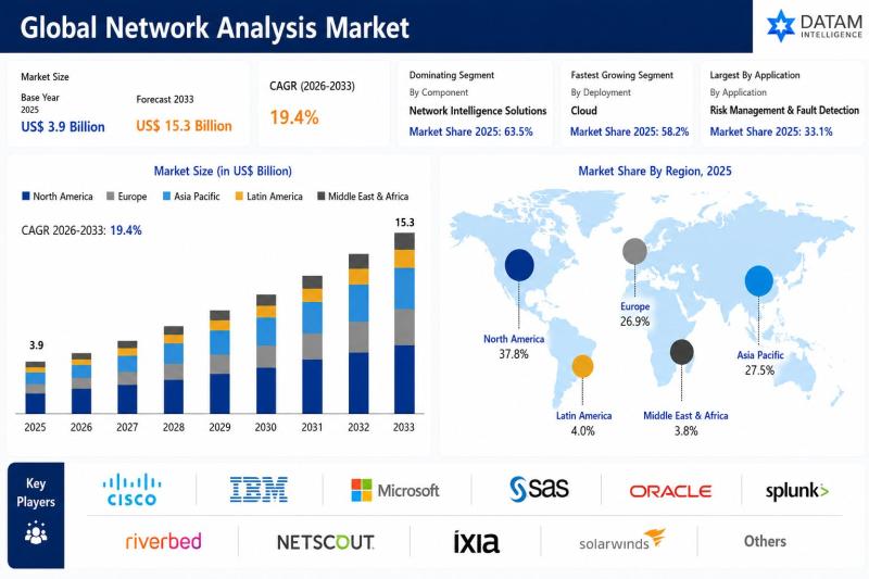
Network Analysis Market to Reach USD 15.3 Billion by 2033 at 19.4% CAGR; North A …
The global network analysis market was valued at USD 3.9 billion in 2025 and is projected to reach nearly USD 15.3 billion by 2033, growing at a CAGR of 19.4% during the forecast period from 2026 to 2033. The market is experiencing rapid growth driven by the increasing complexity of enterprise networks, rising adoption of cloud computing technologies, and growing demand for real time network monitoring and performance optimization solutions.…

Sensors in Mobile Phone Market 2026-2033 | Market Growt to Fiscal Year (Q1) - Mu …
DataM Intelligence has released its latest research report, "Sensors in Mobile Phone Market Size 2026", offering a structured and data-driven assessment of evolving market dynamics and long-term growth potential. The study delivers detailed insights into market sizing, revenue trajectories, CAGR outlook, and regional performance trends, supported by robust segmentation analysis across key industry verticals. The report also highlights emerging growth pockets, investment-aligned opportunities, and areas where innovation and strategic expansion…

Embedded Security Market to Reach USD 14.36 Billion by 2033 at 6.12% CAGR; North …
The global embedded security market was valued at USD 8.92 billion in 2025 and is projected to reach nearly USD 14.36 billion by 2033, growing at a CAGR of 6.12% during the forecast period from 2026 to 2033. The market is witnessing steady growth driven by the increasing adoption of connected devices, rapid expansion of the Internet of Things (IoT), and rising concerns regarding cybersecurity threats across industries. Embedded security…
More Releases for GIS
Complete PDF Guide to Cloud GIS
Increased Demand for Geospatial Data: The demand for geospatial data across industries like agriculture, urban planning, transportation, and logistics is driving the Cloud GIS market.
Download PDF Copy @ https://www.theinsightpartners.com/sample/TIPTE100000932?utm_source=OpenPR&utm_medium=10379
The List of Companies
• CartoDB
• ESRI
• GIS Cloud Ltd
• Google LLC
• Hexagon AB
• Oracle Corporation
• ROK Technologies
• Sourcepole AG
• SuperMap Software Co., Ltd..
Cloud GIS Market Segmentation
Service Model
• Software-as-a-Service
• Platform-as-a-Service
• Infrastructure-as-a-Service
Deployment
• Private Cloud
• Public Cloud
• Community Cloud
• Hybrid Cloud
Application
• Traffic Management
• E-Commerce and Geo Targeted Advertising
• Meteorological
• Scientific Research
• Others
Contact US
Contact Person : Ankit Mathur
Phone : +1-646-491-9876
E-mail : sales@theinsightpartners.com
About US
The Insight Partners…
Integration of BIM & GIS
Building information modeling (BIM) and geographic information systems (GIS) are two technologies that have particular applications. GIS has mapping characteristics and geographical databases, while BIM is primarily utilized for building assets as an object-based information model. In challenging and extensive projects, the connecting thread between these two technologies is gaining legitimacy. BIM technologies are typically used in projects related to architecture and civil engineering, while GIS systems are typically used…
Mobile GIS Market is Anticipated to Gain Moderate CAGR by 2027 | ESRI, GIS Cloud
Mobile GIS market research analysis depicts severe economic consequences caused due to the outbreak COVID-19, which affected the entire society and world economy. Present and previous pricing structure made here helps industry players to bring the right products into the market and gain huge returns. Newly entering market player needs to take the help of this Mobile GIS market research when launching any new product. A few of the vital…
GIS Software Market 2025 by Component, Type of GIS Software, Functions, Organiza …
Increasing adoption of GIS for facilities management, integration of GIS with mainstream technologies for business intelligence, and growing demand for GIS software for smart cities development as well as urban planning have fueled the growth of the global GIS Software Market.
For Purchase Inquiry: https://www.alliedmarketresearch.com/purchase-enquiry/5259
The global GIS software market was valued at $3.24 billion in 2017 and is expected to hit $7.86 billion in 2025, registering a CAGR of 11.8% from…
Global Cloud GIS Sales Market Top player: CartoDB , ESRI , Hexagon, GIS Cloud
The report offers a comprehensive evaluation of the market. It does so via in-depth insights, understanding market evolution by tracking historical developments, and analyzing the present scenario and future projections based on optimistic and likely scenarios. Each research report serves as a repository of analysis and information for every facet of the market, including but not limited to: Regional markets, technology developments, types, applications, and the competitive landscape.
Browse Complete…
Spatial SaaS Provider GIS Cloud Brings Its "GIS For The Masses' Message to Locat …
Boston, Massachusetts September 15, 2010 -- For many organizations realizing the complete benefits of real GIS has become too expensive or too complicated (or both). GIS Cloud's SaaS technology allows full-featured GIS to affordably flow throughout every part of an organization.
In addition to supporting the Li Geocloud 2010 Conference as a Gold Sponsor, GIS Cloud will release the details of its "Freemuim" approach to Geospatial delivery.
GIS Cloud allows anyone with…
