Press release
Commercial Satellite Imaging Market is Projected to Grow USD 10.7 Billion by 2033 | At CAGR 9.7%
Commercial Satellite Imaging Market
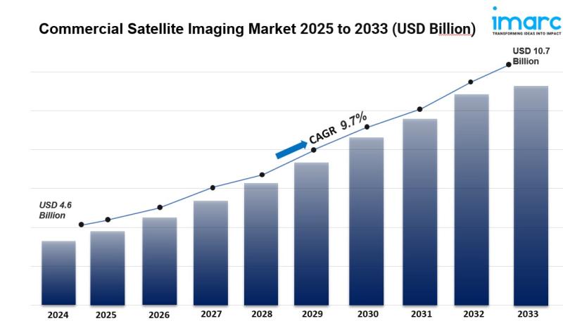
The global Commercial Satellite Imaging Market was valued at USD 4.6 Billion in 2024 and is forecast to reach USD 10.7 Billion by 2033, growing at a CAGR of 9.7% during 2025-2033. This growth is driven by rising demand for real-time data across defense, agriculture, and environmental monitoring sectors, increased investment in space technology, advancements in high-resolution imaging capabilities, and expanded applications in disaster response and geospatial intelligence.
The commercial satellite imaging market is expanding rapidly driven by rising demand for near real-time imagery to track dynamic events such as natural disasters, agricultural health, illegal deforestation, and maritime operations. Growing adoption in defense and intelligence, urban planning, infrastructure development, climate monitoring, and disaster management is accelerating commercial deployment. Advancements in high-resolution optical sensors, synthetic aperture radar (SAR), light detection and ranging (LiDAR), AI-powered analytics, and cloud-based data processing are driving product innovation. The growth of miniaturized satellites, reusable launch vehicles reducing costs, geospatial data integration with GIS platforms, and affordable commercial satellite services is boosting mass market adoption. Increasing demand for location-based services and expanding government space programs further support future global market expansion.
Study Assumption Years
• Base Year: 2024
• Historical Years: 2019-2024
• Forecast Years: 2025-2033
Commercial Satellite Imaging Market Key Takeaways
• Current Market Size (2024): USD 4.6 Billion
• CAGR (2025-2033): 9.7%
• Forecast Period: 2025-2033
• The market is propelled by growing demand for real-time surveillance and monitoring capabilities.
• Increasing adoption in climate monitoring and environmental applications is driving product usage.
• Technological advancements such as high-resolution sensors and AI-based analytics are enhancing data quality.
• Expansion into sectors including defense, agriculture, energy, and disaster management is broadening market horizons.
• High launch costs and regulatory challenges present market obstacles.
Access Detailed Sample Report: https://www.imarcgroup.com/commercial-satellite-imaging-market/requestsample
Market Growth Factors
The commercial satellite imaging market is significantly driven by escalating demand for real-time monitoring and surveillance across multiple sectors. Organizations are progressively depending on near real-time satellite imagery to track dynamic events such as natural disasters, agricultural health monitoring, illegal deforestation activities, and maritime operations. These capabilities facilitate quicker decision-making and response strategies, particularly in emergency situations and continuous monitoring applications. Defense agencies worldwide utilize satellite images for border surveillance, tracking troop movements, target identification, and infrastructure oversight. The military defense sector frequently demands high-resolution, high-frequency imagery, positioning it as one of the most reliable and valuable users of commercial satellite services with 40% market share. Advanced imaging capabilities enable comprehensive intelligence gathering, mission planning, and tactical operations support, making satellite technology an indispensable asset for modern defense strategies.
Climate monitoring and environmental applications represent another major growth factor enhancing the market. Satellite imagery has become essential for environmental observation, providing scalable methods for monitoring deforestation, glacier retreat, ocean temperature variations, air quality measurements, and carbon emissions tracking. With growing impacts of climate change, there is heightened demand from environmental regulators, research organizations, non-governmental organizations, and businesses for reliable data supporting sustainability reporting and regulatory compliance. Satellites deliver consistent, extensive area observations that ground-based systems frequently cannot provide, essential for detecting forest degradation, illegal mining activities, water-level changes, and wildfire spread monitoring. A notable example is Hydrosat's 2024 VanZyl-1 satellite launch, the first commercial satellite providing high-resolution thermal imagery with global coverage, aimed at evaluating crop health and identifying water stress for climate models and agricultural strategies.
Technological advancements are transforming the commercial satellite imaging landscape. Contemporary satellites provide improved resolution, faster data transfer capabilities, and superior imaging features including multispectral and hyperspectral sensing. Miniaturization of components is making small satellites more affordable and accessible, while reusable launch vehicles are significantly reducing launch expenses. Advancements in GPS satellites, electric propulsion technologies, high-resolution optical sensors, remote sensing capabilities, and LiDAR systems are improving accuracy, speed, and adaptability of satellite images. These technologies enable enhanced spatial resolution, immediate updates, and more extensive data layers, rendering satellite imaging essential across transportation, infrastructure, agriculture, and environmental surveillance sectors. Integration with AI-powered analytics, machine learning algorithms, and cloud-based platforms facilitates faster decision-making and broadens practical applications.
Market Segmentation
Technology:
• Optical: Dominates the market with 65.5% share due to capability to obtain high-resolution, true-color images that are straightforward to analyze and broadly applicable across various sectors. Optical sensors gather data in visible and near-infrared spectrum, ideal for land cover mapping, agricultural tracking, urban planning, and environmental assessment.
• Radar: Including Synthetic Aperture Radar (SAR), provides all-weather, day-night imaging capabilities, essential for continuous monitoring regardless of cloud cover or lighting conditions.
Application:
• Geospatial Data Acquisition and Mapping: Largest application segment, widely used across urban planning, environmental oversight, infrastructure development, and natural resource management sectors requiring precise spatial information for comprehensive topographical assessment and land-use classification.
• Urban Planning and Development: Supporting smart city initiatives, infrastructure monitoring, and sustainable development planning.
• Disaster Management: Enabling rapid assessment, emergency response coordination, and recovery planning through real-time imagery.
• Energy and Natural Resource Management: Monitoring oil and gas infrastructure, mining operations, and renewable energy installations.
• Surveillance and Security: Border monitoring, maritime surveillance, and critical infrastructure protection.
• Defense and Intelligence: Military reconnaissance, strategic planning, and national security applications.
• Others: Including agriculture monitoring, transportation logistics, and archaeological surveys.
End User:
• Military Defense: Leading segment with 40.0% market share, driven by continuous substantial demand for high-resolution, real-time images supporting national security, surveillance, and tactical missions with requirements for global coverage and all-weather imaging capabilities.
• Government: Civilian agencies for mapping, land management, and regulatory compliance.
• Forestry and Agriculture: Precision agriculture, crop health monitoring, and forest management.
• Energy: Infrastructure monitoring, exploration support, and pipeline surveillance.
• Civil Engineering and Archaeology: Site planning, cultural heritage preservation, and geological surveys.
• Transportation and Logistics: Route optimization, traffic monitoring, and supply chain management.
• Others: Including insurance, environmental organizations, and academic research.
Resolution:
• Low Resolution: Cost-effective solutions for large-scale monitoring.
• Medium Resolution: Balanced performance for general applications.
• High Resolution: Premium imaging for detailed analysis and precision applications.
• Very High Resolution: Advanced capabilities for specialized defense and intelligence requirements.
Region:
• North America
• Europe
• Asia Pacific
• Latin America
• Middle East and Africa
Regional Insights
North America is the leading regional market for commercial satellite imaging, holding the largest market share of 38.7% globally. The growth is driven by robust institutional support, technological advancement, and substantial investment in space and geospatial technologies. The region features a developed ecosystem with prominent satellite manufacturers, service providers, and data analytics companies enabling seamless integration of imaging services across multiple industries. Strong government and private sector investment in space-based technologies, widespread adoption of advanced geospatial solutions, and well-established research and development infrastructure support market dominance. Advanced digital infrastructure and data-driven decision-making culture accelerate adoption of satellite imaging solutions that integrate easily into operational systems. The United States accounts for 85.90% of North American market share, driven by increasing concerns about climate change and environmental damage.
In 2024, the United States encountered 27 climate-related disasters each exceeding USD 1 billion in damages, highlighting growing environmental impacts requiring advanced imaging technologies.
Asia Pacific represents the fastest-growing regional market with significant expansion potential. The uptake of commercial satellite imagery is accelerating rapidly, primarily fueled by rising implementation of GPS satellites and expansion of space-based infrastructure. India's GPS system comprises 31 satellites with 24 operational units orbiting at approximately 20,000 kilometers altitude, creating essential foundation for GPS-based services supporting precise navigation, mapping, and extensive geospatial data gathering. Enhanced precision in location tracking and real-time monitoring benefits precision agriculture, smart transportation systems, streamlined logistics, and urban planning. Increasing satellite data accessibility aids disaster response, environmental monitoring, and sustainable land-use practices while enhancing operational efficiencies in remote or underserved areas.
Europe experiences steady growth driven by increasing security concerns and rising geopolitical tensions, particularly from ongoing conflicts and changing alliances. The continuous war in Ukraine, with Russia incurring expenses ranging from USD 500 million to USD 1 billion daily, is encouraging European countries to increase defense spending and enhance surveillance, reconnaissance, and intelligence capabilities. Commercial satellite imagery provides high-resolution, real-time information enabling continuous border surveillance, troop movement monitoring, and threat detection. Canada's 2024 federal budget announced USD 8.6 million for the Lunar Exploration Accelerator Program and USD 6.9 billion toward space-based defense initiatives including Arctic surveillance and communications systems.
Recent Developments & News
In April 2025, China announced plans for a space traffic management system to address growing congestion in low Earth orbit, where projections indicate up to 100,000 satellites could operate. The China National Space Administration emphasizes ensuring space sustainability and preventing satellite project conflicts, with commercial satellite imaging playing a significant role in these initiatives.
In March 2025, Digantara commissioned SCOT, a commercial space surveillance satellite. Launched aboard SpaceX's Transporter-12 rocket, SCOT began operations capturing high-resolution commercial satellite imaging over South America, capable of tracking objects as small as 5 centimeters in orbit.
In March 2025, SpaceEye-T, a commercial Earth observation satellite developed by South Korea's Satrec Initiative and operated by SI Imaging Services, was launched. It offers native optical resolution of 25 centimeters, making it one of the most advanced commercial imaging satellites available, with 12 kilometer swath width supporting rapid image delivery capturing up to 300,000 square kilometers per day.
In March 2025, BlackSky announced its Gen-3 satellite delivered very high-resolution imagery just five days after launching. The company provided first light satellite images of Sydney International Airport and Sydney Harbor Bridge, surpassing customer expectations with minimal calibration and reducing commissioning timeline from months to days.
In 2024, Hyderabad-based Dhruva Space launched AstraView, a commercial satellite imagery service offering high-resolution, real-time Earth observation data. The service was backed by partnerships with global satellite firms providing diverse imagery types, targeting users in academia, defense, and enterprise sectors.
In 2024, Hydrosat launched VanZyl-1 satellite through SpaceX's Transporter-11 in early July. VanZyl-1 was the first commercial satellite providing high-resolution thermal imagery with global coverage, aimed at evaluating crop health and identifying water stress with data directly used in climate models and agricultural strategies.
In October 2024, Indian Railways released tenders valued at ₹3,200 crore for LiDAR system installation on trains and railway tracks, producing extremely precise digital elevation models and identifying obstacles, erosion, or intrusions with minimal human involvement.
Key Players
• Airbus S.A.S.
• BlackSky Technology Inc.
• EarthDaily Analytics (UrtheCast Corp.)
• European Space Imaging GmbH
• Galileo Group Inc.
• L3Harris Technologies Inc.
• Maxar Technologies Inc.
• Planet Labs Inc.
• Skylab Analytics
• SpaceKnow Inc.
• Satellogic Inc.
• ImageSat International N.V.
• Capella Space Corp.
• ICEYE
• SI Imaging Services (SIIS)
If you require any specific information that is not covered currently within the scope of the report, we will provide the same as a part of the customization.
Expert Insights Available - Connect With Our Analysts: https://www.imarcgroup.com/request?type=report&id=4311&flag=C
About Us
IMARC Group is a global management consulting firm that helps the world's most ambitious changemakers to create a lasting impact. The company provide a comprehensive suite of market entry and expansion services. IMARC offerings include thorough market assessment, feasibility studies, company incorporation assistance, factory setup support, regulatory approvals and licensing navigation, branding, marketing and sales strategies, competitive landscape and benchmarking analyses, pricing and cost research, and procurement research.
Contact Us
IMARC Group,
134 N 4th St. Brooklyn, NY 11249, USA,
Email: sales@imarcgroup.com,
Tel No: (D) +91 120 433 0800,
United States: +1-201-971-6302
This release was published on openPR.
Permanent link to this press release:
Copy
Please set a link in the press area of your homepage to this press release on openPR. openPR disclaims liability for any content contained in this release.
You can edit or delete your press release Commercial Satellite Imaging Market is Projected to Grow USD 10.7 Billion by 2033 | At CAGR 9.7% here
News-ID: 4361603 • Views: …
More Releases from IMARC Group

Brazil Telecom Market Report 2026-34: For Telecom Operators & Network Service Pr …
Brazil Telecom Market Summary:
• The Brazil Telecom Market reached USD 24.23 Billion in 2025.
• The market is projected to reach USD 37.89 Billion by 2034.
• Southeast dominates with a significant market share.
• Growth is driven by rapid 5G deployment, rising mobile data consumption, and increasing investments in fiber-optic broadband infrastructure.
IMARC Group, a leading market research company, has released its latest report titled "Brazil Telecom Market Report 2026-2034." The study provides…

Brazil Construction Market Report 2026-2034: Insights for Construction Companies …
Brazil Construction Market Summary:
• The Brazil Construction Market size reached USD 155.98 Billion in 2025.
• The market is projected to reach USD 218.19 Billion by 2034.
• Southeast dominates with a significant market share.
• Growth is driven by rising infrastructure investments, expanding residential and commercial construction activities, and increasing adoption of sustainable building technologies.
IMARC Group, a leading market research company, has released its latest report titled "Brazil Construction Market." The study…

Precision Agriculture Market to USD 22.5 Billion by 2034 with a Robust CAGR of 9 …
Precision Agriculture Market Summary
• The Precision Agriculture Market was valued at USD 10.2 Billion in 2025.
• The market is projected to reach USD 22.5 Billion by 2034.
• The market is expected to expand at a CAGR of 9.18% during 2026-2034.
• Rising adoption of GPS-guided equipment and connected farming technologies is improving field productivity.
• Increasing use of drones, sensors, and satellite imagery is helping farmers monitor crop health with greater accuracy.
• Government…

Latin America Cyber Security Market to Hit USD 41.03 Billion by 2034 with a Robu …
Latin America Cyber Security Market Summary
• The Latin America Cyber Security Market was valued at USD 23.06 Billion in 2025.
• The market is projected to reach USD 41.03 Billion by 2034.
• The market is expected to expand at a CAGR of 6.61%during 2026-2034.
• Increasing cyberattacks against financial institutions, healthcare organizations, and government agencies are strengthening demand for advanced security solutions.
• Rapid digital transformation across enterprises is encouraging greater investment in cloud,…
More Releases for Imaging
Mobile Gamma Cameras Market 2018 -- 2028 | By Indication Type (Cardiac Imaging, …
Mobile gamma camera is a portable version of the stationary gamma or angler camera used for nuclear imaging. Nuclear imaging involves injecting a radio nucleotide in the body or organ under study and record the resulting redioactivity by scanning with a gamma camera. Nuclear imaging is performed owing to its better resolution and selectivity than non-nuclear imaging such as MRI and ultrasound.
The mobile gamma camera types include single, dual and…
Holographic Imaging Market Latest Technological Innovations on Holoxica, Zebra I …
Market Study Report Adds Global Holographic Imaging Market Size, Status and Forecast 2024 added to its database. The report provides key statistics on the current state of the industry and other analytical data to understand the market.
Emergence of 3D holographic imaging has revolutionized the medical imaging and surgery. The technology converts the given two dimensional MRI and CT scan imaging data into interactive virtual reality images. Using these images doctors…
Holographic Imaging Market : Eminent Players – EON Reality, Holoxica, Zebra Im …
Holographic Imaging Market size is set to exceed USD 3 billion by 2024; according to a new research study published by Global Market Insights, Inc.
Increasing adoption of holographic imaging in medical education should drive the holographic imaging market size over the forecast years. Medical practitioners and students are widely using holographic techniques to effectively study the human body, since the technology provides surgeons with a detailed view of patient…
Holographic Imaging Market Eminent Players – EON Reality, Holoxica, Zebra Imag …
Holographic Imaging Market size is set to exceed USD 3 billion by 2024; according to a new research study published by Global Market Insights, Inc.
Increasing adoption of holographic imaging in medical education should drive the holographic imaging market size over the forecast years. Medical practitioners and students are widely using holographic techniques to effectively study the human body, since the technology provides surgeons with a detailed view of patient anatomy…
Holographic Imaging Market Projections Reviewed On Holoxica, Zebra Imaging, Oviz …
The newly released research at Market Study Report titled “2017-2024 Global Holographic Imaging Consumption Market Report” provides data, information, brief analysis, company profiles, statistics for past years and forecasts for next few years.
Holographic Imaging Market size is set to exceed USD 3 billion by 2024. U.S. holographic imaging market accounted for significant industry share with expectations to witness healthy growth over coming years. Increasing biomedical research initiatives in holographic image…
Digital Imaging Market,Digital Imaging Industry, Global Digital Imaging Market,D …
Latest industry research report on: Global Digital Imaging Market : Industry Size, Share, Research, Reviews, Analysis, Strategies, Demand, Growth, Segmentation, Parameters, Forecasts
This report presents the worldwide Digital Imaging market size (value, production and consumption), splits the breakdown (data status 2013-2018 and forecast to 2025), by manufacturers, region, type and application.
This study also analyzes the market status, market share, growth rate, future trends, market drivers, opportunities and challenges, risks and entry…
