Press release
Navigating the Future: Digital Mapping Aerial Photography Market Trends and Forecast Insights, 2025 Edition

Digital Mapping Aerial Photography
Digital Mapping Aerial Photography Market Size Growth Forecast: What to Expect by 2025?
The size of the digital mapping aerial photography market has seen significant growth in the past few years. It is projected to increase from a valuation of $2.38 billion in 2024 to $2.6 billion in 2025, with a compound annual growth rate (CAGR) of 9.2%. That increase during the historic period is due to factors such as the development of urban planning, the broadening of infrastructure projects, increased monitoring of agricultural land, a surge in defense and surveillance demand, as well as early adoption by governmental bodies.
How Will the Digital Mapping Aerial Photography Market Size Evolve and Grow by 2029?
Anticipated robust expansion is forecasted for the digital mapping aerial photography sector in the ensuing years, with the market size projected to reach $3.65 billion by 2029, fueled by an 8.9% compound annual growth rate (CAGR). This predicted upswing in the estimation timeframe is largely due to the escalating requirement for real-time geospatial data, advancements in smart city initiatives, growth in autonomous vehicle navigation, increased need for precision farming, and incorporation with geographical information systems. Major trends expected to shape the market during the forecast duration include advancements in airborne imaging sensors, the emergence of high-resolution image creation technologies, innovations in drone-based cartographic systems, artificial intelligence integration in image analytics, and advancements in 3D cartography and modelling research.
View the full report here:
https://www.thebusinessresearchcompany.com/report/digital-mapping-aerial-photography-global-market-report
What Drivers Are Propelling the Growth of Digital Mapping Aerial Photography Market Forward?
The surge in real estate and construction endeavors is projected to fuel the expansion of the digital mapping aerial photography market in the future. This surge is motivated by urbanization, resulting in increased demand for housing and infrastructure in burgeoning cities. The essential activities in real estate and construction include property transactions, enhancements, and establishment of infrastructure projects. Digital mapping aerial photography significantly aids these activities by providing high-precision visuals and precise topographical information for strategic planning and evaluation of sites. For example, the Office for National Statistics, a government department in the UK, reported in November 2023 that new construction undertakings witnessed a revenue increase of £18,161 million ($19.96 million) in 2022. This comprised a growth of 16.8% in private sector projects and a 13.1% rise in public sector projects. Consequently, the booming real estate and construction industry is catalyzing the expansion of the digital mapping aerial photography market.
Get your free sample here:
https://www.thebusinessresearchcompany.com/sample.aspx?id=24950&type=smp
What Long-Term Trends Will Define the Future of the Digital Mapping Aerial Photography Market?
Prominent corporations in the aerial photography digital mapping domain are prioritizing the evolution of high-tech products like aerial mapping cameras to amplify image quality and data precision. These cameras are specifically designed to be installed on drones or aircraft to take high-definition photos of the Earth's surface to produce intricate maps and geographical information. An example is when, in October 2023, Phase One A/S, a company based in Denmark known for its superior digital photography gear and software, unveiled the PAS Pana, a wide-range camera. This camera boasts a seven-camera configuration, where five RGB cameras come with 150 mm lenses, and two NIR cameras use 70 mm lenses. These cameras collectively provide around 48,800 pixels in the direction of the flight. Such a system is designed for highly effective nation-to-nation mapping as it can capture expansive areas in the least possible time. Ground sampling distances can vary from 2.5 cm to 30 cm, making the PAS Pana perfect for mapping on a larger scale, corridor mapping, as well as 3D urban modeling.
What Are the Key Segments in the Digital Mapping Aerial Photography Market?
The digital mapping aerial photography market covered in this report is segmented -
1) By Type Of Aerial Photography: Traditional Aerial Photography, Drone-Based Aerial Photography, Satellite Imagery, High-Resolution Aerial Photography
2) By Technology: Photogrammetry, Light Detection And Ranging (LiDAR), Computer Vision, Geographic Information System Integration, Three-Dimensional (3D) Modeling And Visualization
3) By Geographic Coverage: Local Mapping, Regional Mapping, National Mapping, Global Mapping
4) By Application: Urban Planning, Agriculture And Forestry, Environmental Monitoring, Mining And Resource Exploration, Infrastructure Development
5) By End-User Industry: Government And Public Sector, Construction And Real Estate, Transportation And Logistics, Energy And Utilities, Telecommunications
Subsegments:
1) By Traditional Aerial Photography: Film-Based Aerial Photography, Analog Aerial Cameras, Infrared Film Photography, Panchromatic Film Photography
2) By Drone-Based Aerial Photography: Fixed-Wing Drones, Multi-Rotor Drones, Hybrid Vertical Take-Off and Landing (VTOL) Drones, Thermal Imaging Drones, Multispectral Imaging Drones
3) By Satellite Imagery: Optical Satellite Imagery, Radar Satellite Imagery (SAR), Hyperspectral Satellite Imagery, Geostationary Satellite Imagery, Low Earth Orbit (LEO) Satellite Imagery
4) By High-Resolution Aerial Photography: Ultra-High Resolution Cameras, Light Detection And Ranging (LiDAR)-Integrated Aerial Photography, Multispectral High-Resolution Imaging, Panchromatic High-Resolution Imaging
Tailor your insights and customize the full report here:
https://www.thebusinessresearchcompany.com/customise?id=24950&type=smp
Who Are the Key Players Shaping the Digital Mapping Aerial Photography Market's Competitive Landscape?
Major companies operating in the digital mapping aerial photography market are Airbus, Teledyne Technologies Inc., Leica Geosystems AG, EagleView Technologies Inc., Vexcel Imaging GmbH, Planet Labs PBC, Pix4D S.A., Phase One A/S, CycloMedia Technology B.V., Kucera International Inc., Cooper Aerial Surveys Co., Digital Aerial Solutions LLC, SkyIMD Inc., SimActive Inc., Landiscor, Mapware Inc., IGI Systems GmbH, Share UAV Technology Co. Ltd., DAS Geospatial LLC, Aerial Mapping Consultants Inc.
What Geographic Markets Are Powering Growth in the Digital Mapping Aerial Photography Market?
North America was the largest region in the digital mapping aerial photography market in 2024. Asia-Pacific is expected to be the fastest-growing region in the forecast period. The regions covered in the digital mapping aerial photography market report are Asia-Pacific, Western Europe, Eastern Europe, North America, South America, Middle East, Africa.
Purchase the full report today:
https://www.thebusinessresearchcompany.com/purchaseoptions.aspx?id=24950
This Report Supports:
1. Business Leaders & Investors - To identify growth opportunities, assess risks, and guide strategic decisions.
2. Manufacturers & Suppliers - To understand market trends, customer demand, and competitive positioning.
3. Policy Makers & Regulators - To track industry developments and align regulatory frameworks.
4. Consultants & Analysts - To support market entry, expansion strategies, and client advisory work.
Connect with us on:
LinkedIn: https://in.linkedin.com/company/the-business-research-company,
Twitter: https://twitter.com/tbrc_info,
YouTube: https://www.youtube.com/channel/UC24_fI0rV8cR5DxlCpgmyFQ.
Contact Us
Europe: +44 7882 955267,
Asia: +91 88972 63534,
Americas: +1 310-496-7795 or
Email: mailto:info@tbrc.info
Learn More About The Business Research Company
With over 15,000+ reports from 27 industries covering 60+ geographies, The Business Research Company has built a reputation for offering comprehensive, data-rich research and insights. Our flagship product, the Global Market Model delivers comprehensive and updated forecasts to support informed decision-making.
This release was published on openPR.
Permanent link to this press release:
Copy
Please set a link in the press area of your homepage to this press release on openPR. openPR disclaims liability for any content contained in this release.
You can edit or delete your press release Navigating the Future: Digital Mapping Aerial Photography Market Trends and Forecast Insights, 2025 Edition here
News-ID: 4094251 • Views: …
More Releases from The Business Research Company
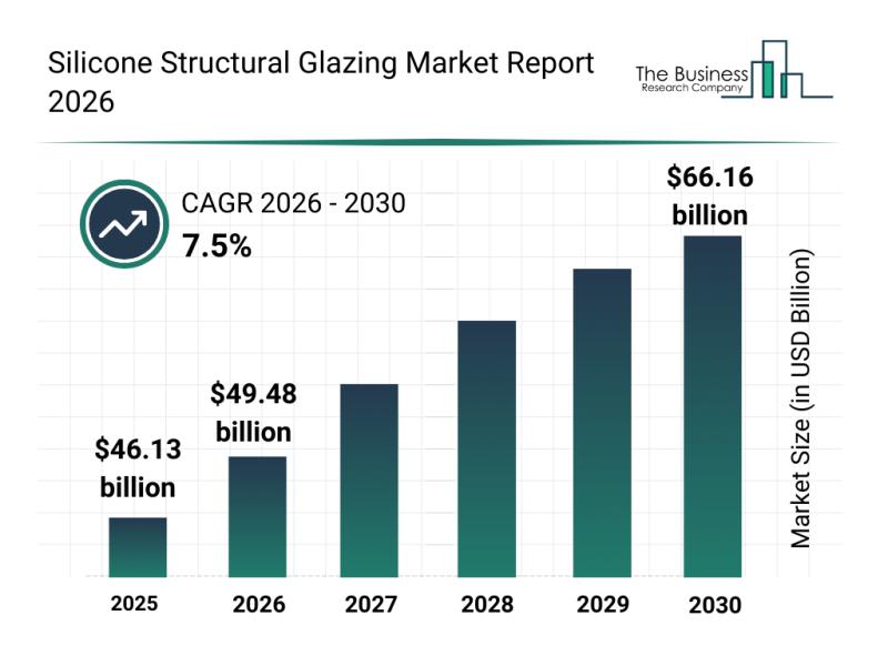
Leading Companies Solidify Their Presence in the Silicone Structural Glazing Mar …
The silicone structural glazing market is positioned for significant expansion in the coming years, driven by advances in building technology and increased environmental awareness. This sector is evolving rapidly as demand grows for more energy-efficient and aesthetically appealing architectural solutions. Let's explore the market's current size, key players, emerging trends, and the main segments that are shaping its future.
Silicone Structural Glazing Market Value Forecast Through 2030
The market for silicone…
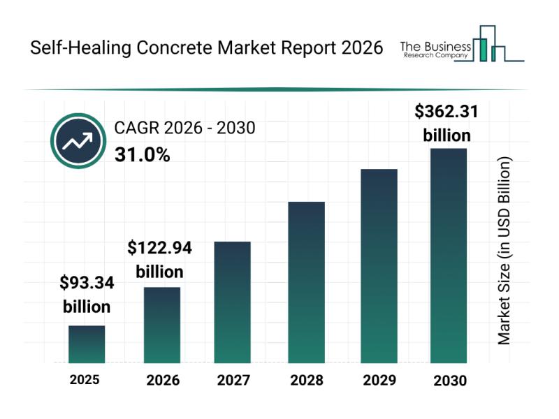
Future Prospects: Key Trends Shaping the Self-Healing Concrete Market up to 2030
The self-healing concrete market is capturing significant attention as innovations and sustainability demands rise in construction. This sector is set to experience remarkable growth due to advancements in materials and technology, shaping the future of durable and intelligent infrastructure solutions. Let's explore the market's size, key players, emerging trends, and segment outlook to understand its trajectory.
Projected Market Size and Growth Prospects for the Self-Healing Concrete Market
The self-healing concrete market…

Analysis of Key Market Segments Driving the ROS-Based Robot Industry
The ROS-based robot market is positioned for substantial growth as robotics technology continues to advance rapidly. With increasing innovation in software, hardware, and AI integration, this sector is set to transform multiple industries by 2030. Below, we explore the market's future size, leading companies, key trends, and segmentation details to understand its evolving landscape.
Projected Market Size and Expansion of the ROS-Based Robot Market
The ROS-based robot market is anticipated to…

Global Trends Overview: The Rapid Evolution of the Robotic Panelized Home Builde …
The robotic panelized home builder market is positioned for impressive growth in the coming years as automation and robotics increasingly transform construction processes. Driven by technological advancements and expanding prefab housing projects, this market is set to reshape how homes are built with greater speed and efficiency. Let's explore the market's size, leading companies, emerging trends, and key segments that are shaping its future.
Strong Growth Forecast for the Robotic Panelized…
More Releases for Aerial
Aerial Advertising Market Is Booming Worldwide | Aerial Opportunities, Aerial Be …
The latest study released on the Global Aerial Advertising Market by AMA Research evaluates market size, trend, and forecast to 2027. The Aerial Advertising market study covers significant research data and proofs to be a handy resource document for managers, analysts, industry experts and other key people to have ready-to-access and self-analyzed study to help understand market trends, growth drivers, opportunities and upcoming challenges and about the competitors.
Key Players in…
Aerial Survey Market Trends 2022: Insight Robotics, Geosense, Blom ASA, Digital …
Aerial Survey Market research report identifies, assesses, and analyses the up-and-coming trends along with major drivers, restraints, challenges, and opportunities in the market for the IT & Telecommunication industry. The report contains estimations of CAGR values, market drivers, and market restraints about the IT & Telecommunication industry which are helpful for businesses in deciding upon numerous strategies. The market type, organization size, availability on-premises, end-users organization type, and the availability…
Aerial Survey Services Market Exceptional Business Performance | EagleView Techn …
Report Ocean recently published a new report on the Global Aerial Survey Services Market. The study has an in-depth analysis of the forecast period from 2021-2025. The report reveals a comprehensive picture of the Aerial Survey Services Market situation, taking into consideration all major trends, market dynamics, and competitive factors. Additionally, the report contains key statistics concerning the Aerial Survey Services Market situation of the leading key players, key market…
Aerial Imaging Market 2020 Outlook & Implications for Business by Eagle Aerial S …
According to a new report published by Allied Market Research, titled, "Aerial Imaging Market by Application (Geospatial Mapping, Disaster Management, Energy and Resource Management, Surveillance and Monitoring) and End User (Government, Military & defense, Energy and resource management, Agriculture & forestry, Civil engineering, Commercial, Media & entertainment) - Global Opportunity Analysis and Industry Forecast, 2020-2030." The report has offered an all-inclusive analysis of the global Aerial Imaging Market taking into…
Aerial Imaging Market - Product Experts Ideas by Blom, Eagle View Technologies, …
Asia-Pacific is projected to be the fastest growing aerial imaging markets during the forecast period due to the increase in economic growth, rapid industrialization, and growth in number of natural disasters such as landslide, earthquakes, and floods in countries such as India, China, Japan, Singapore, and others.
Schedule a Call with Our Analysts/Industry Experts To Find Solution For Your Business: https://www.alliedmarketresearch.com/connect-to-analyst/294
Blom ASA, Eagle View Technologies, Inc., Digital Aerial Solutions, LLC,…
Aerial Imaging Market - Evolution of Aerial Imaging In Coming 10 Years, Analysis …
Aerial Imaging Market 2022 - Asia-Pacific is projected to be the fastest growing aerial imaging markets during the forecast period due to the increase in economic growth, rapid industrialization, and growth in number of natural disasters such as landslide, earthquakes, and floods in countries such as India, China, Japan, Singapore, and others.
Download Report Sample (120 Pages PDF with Insights): https://www.alliedmarketresearch.com/request-sample/294
Key Findings of Aerial Imaging Market
o In 2015, government segment dominated…
