Press release
Aerial Imaging Market to Surpass USD 11.1 Billion by 2034, Growing at 7.7% CAGR
The global Aerial Imaging Market was valued at USD 5.0 billion in 2023 and is projected to reach USD 11.1 billion by the end of 2034, growing at a robust CAGR of 7.7% from 2024 to 2034. This growth is driven by increasing demand across sectors such as agriculture, urban planning, defense, and environmental monitoring, where high-resolution imagery is critical for data-driven decision-making and efficient resource management.Expansion in construction sector is propelling the aerial imaging market size. Aerial imagining is employed in the construction sector to enhance decision-making, safety, and project efficiency. Aerial construction technology uses sensors and advanced imaging techniques to ensure precise data collection.
Rise in demand for geospatial technology is driving the aerial imaging market trajectory. Aerial photos are widely utilized in geospatial analytics in tracking urban development, evaluating infrastructure projects, designing utility networks, and crop health monitoring.
Dive Deeper into Data: Get Your In-Depth Sample Now! https://www.transparencymarketresearch.com/sample/sample.php?flag=S&rep_id=49734
Key players in the global market are developing advanced, progressively designed, and seamlessly integrated hybrid aerial mapping systems to cater to customer needs.
Market Segmentation
The aerial imaging market can be segmented based on various factors, providing a comprehensive view of its diverse applications and operational models:
By Service Type:
Platform Services: This segment includes flight piloting and operation, data analysis, and data processing.
Maintenance, Repair, and Operations (MRO): Services related to the upkeep and repair of aerial imaging equipment.
Simulation and Training: Training programs for aerial imaging operators and analysts.
End-to-End Solutions: Comprehensive services covering the entire aerial imaging workflow.
Point Solutions: Specific services focused on particular aspects like surveying or inspection.
By Sourcing Type: While explicit "sourcing type" segmentation isn't detailed in the provided information, it generally refers to how the imaging services are acquired, which could include:
In-house: Organizations owning and operating their aerial imaging equipment.
Outsourced (Service Providers): Engaging third-party companies specializing in aerial imaging.
By Application:
Geospatial Mapping: The largest application, crucial for urban planning, land-use analysis, and creating detailed maps.
Disaster Management: Essential for damage assessment, relief efforts, and monitoring recovery post-natural disasters.
Energy and Resource Management: Used for monitoring oil and gas pipelines, power lines, and assessing natural resources.
Surveillance and Monitoring: Employed for security, border control, wildlife monitoring, and infrastructure inspection.
Urban Planning: Critical for city development, infrastructure projects, and monitoring urban growth.
Conservation and Research: For environmental studies, ecosystem monitoring, and tracking climate change impacts.
Agriculture (Precision Farming): Crop health monitoring, yield estimation, and optimized resource management.
Infrastructure Inspection: Assessing the condition of bridges, roads, railways, and other infrastructure.
By Industry Vertical:
Government: A dominant end-user, utilizing aerial imaging for national security, urban planning, environmental protection, and disaster response.
Military and Defense: For surveillance, reconnaissance, mapping, and strategic planning.
Agriculture and Forestry: For precision farming, crop monitoring, land management, and forestry mapping.
Civil Engineering & Construction: For site planning, progress tracking, volume calculations, and infrastructure development.
Energy (Oil & Gas, Utilities): For pipeline inspection, facility monitoring, and resource exploration.
Media and Entertainment: For filming, photography, and creating immersive content.
Real Estate: For property visualization, site analysis, and marketing.
Mining: For surveying mineral deposits, monitoring site safety, and stockpile measurement.
Insurance: For damage assessment and claims processing.
By Region:
North America: Held the largest market share in 2024 (e.g., USD 1.60 billion in 2024 for overall market, or 36.2% for specific segments), driven by early adoption of advanced technologies, presence of key players, and robust applications in agriculture, construction, and defense. The U.S. is a significant market within this region.
Asia Pacific: Expected to exhibit the fastest growth and highest CAGR between 2025 and 2034. This is attributed to rapid urbanization, infrastructure development (especially in China and India), increasing government budgets, and rising demand for drones.
Europe: Significant growth, particularly in countries like the UK, Germany, and France, driven by the presence of major manufacturers and increasing drone usage in agriculture and other sectors.
Latin America: An emerging market with growing applications in agriculture and industrial sectors.
Middle East & Africa: Driven by increasing applications in tourism and growing industrial needs.
Regional Analysis
North America continues to be a dominant force in the aerial imaging market, characterized by significant investments in drone technology and widespread adoption across various industries. However, the Asia Pacific region is poised for the most rapid expansion, fueled by burgeoning economic opportunities, infrastructure projects, and increasing government spending on geospatial technologies. Europe also demonstrates strong growth, driven by technological advancements and the integration of aerial imaging in diverse commercial and environmental applications.
Market Drivers and Challenges
Market Drivers:
Increasing Demand for High-Resolution Imagery: Growing need for detailed and accurate data across industries like urban planning, agriculture, and construction.
Technological Advancements in Drones and Sensors: Development of more affordable, efficient, and high-resolution imaging systems, including LiDAR, hyperspectral imaging, and 3D mapping capabilities.
Rise in Precision Agriculture: Aerial imaging plays a crucial role in optimizing crop yields, monitoring soil health, and improving farming efficiency.
Growing Incidents of Natural Disasters: Increasing frequency and intensity of natural calamities necessitate rapid and effective aerial imaging for damage assessment and disaster management.
Expansion of Commercial Drone Services: The proliferation of drone technology for various commercial applications, from real estate to package delivery.
Government Initiatives and Smart City Development: Government investments in infrastructure projects and smart city initiatives drive the demand for comprehensive mapping and monitoring.
Integration with GIS and AI/ML: Seamless integration with Geographic Information Systems (GIS) and the application of Artificial Intelligence (AI) and Machine Learning (ML) for advanced data processing and analysis.
Market Challenges:
Regulatory Hurdles and Airspace Restrictions: Strict regulations on drone operation and airspace usage can limit market expansion.
Data Security and Privacy Concerns: The collection of high-resolution aerial data raises concerns regarding privacy and the security of sensitive information.
High Initial Investment Costs: The cost of acquiring advanced aerial imaging platforms and processing software can be a barrier for some smaller businesses.
Technical Expertise Requirement: Operating and analyzing aerial imaging data requires specialized skills and training.
Market Trends
Integration of AI and Machine Learning: AI and ML algorithms are increasingly being used for automated image analysis, object detection, and predictive modeling, enhancing efficiency and accuracy.
3D Mapping and Photogrammetry: Growing demand for 3D models of landscapes, buildings, and infrastructure for detailed planning and visualization.
Hyperspectral and Multispectral Imaging: Adoption of advanced imaging techniques for more comprehensive data collection, particularly in agriculture and environmental monitoring.
Cloud-based Platforms: Shift towards cloud-based solutions for data storage, processing, and collaborative access to aerial imagery.
Miniaturization and Affordability of Drones: Development of smaller, more cost-effective drones makes aerial imaging accessible to a wider range of users.
Subscription-based Pricing Models: Increasing popularity of subscription services for accessing aerial imagery data.
Future Outlook
The aerial imaging market is poised for continued strong growth, driven by ongoing technological advancements and the expansion of its application across diverse sectors. The increasing adoption of drone technology, coupled with the integration of AI and 3D modeling, will further revolutionize data collection and analysis. The market is expected to play an even more critical role in areas like climate change monitoring, sustainable development, and intelligent infrastructure management. The convergence of various technologies promises a future where aerial imaging provides real-time, actionable insights for complex global challenges.
Key Market Study Points
Analysis of market size, growth rates, and forecasts across different segments.
In-depth examination of technological advancements in imaging sensors, platforms, and data processing.
Assessment of regulatory landscapes and their impact on market growth.
Identification of emerging applications and opportunities in untapped markets.
Understanding the competitive strategies of key players and market consolidation trends.
Evaluation of investment opportunities and strategic partnerships.
Competitive Landscape
The aerial imaging market is characterized by a mix of established players and emerging innovators. Key companies are focusing on technological differentiation, strategic partnerships, and geographic expansion to gain a competitive edge.
Some of the prominent players in the aerial imaging market include:
EagleView Technologies, Inc.
Nearmap Ltd.
Fugro N.V.
Kucera International Inc.
Digital Aerial Solutions, LLC
Cooper Aerial Surveys Co.
Aeroptic, LLC (GeoVantage, Inc.)
Global UAV Technologies Ltd.
SZ DJI Technology Co., Ltd.
Bluesky International
Maxar Technologies
Woolpert
These companies are investing heavily in research and development to offer advanced solutions with higher resolution, faster processing, and integrated analytics.
Buy this Premium Research Report: https://www.transparencymarketresearch.com/refueling-aircraft-market.html
Recent Developments
February 2024: Nearmap expanded its AI-powered aerial imagery services in the U.S. and Australia, enhancing high-resolution data availability for sectors like insurance and urban planning.
January 2024: EagleView Technologies launched its next-generation EagleView Cloud platform, combining ultra-high-resolution aerial imagery with real-time geospatial analytics for construction, public safety, and disaster management.
October 2023: Bluesky International secured a contract to supply aerial LiDAR data for the UK Environment Agency's flood risk modeling, highlighting aerial imaging's role in climate resilience.
September 2023: Maxar Technologies partnered with Esri to integrate its Vivid and Metro satellite imagery into Esri's ArcGIS Living Atlas, improving access to high-resolution base maps.
July 2023: Woolpert acquired AAM Group, expanding its global aerial imaging capabilities, particularly in the Asia-Pacific region.
February 2024: AIRmarket and Alberta announced a significant investment in Canada's first RPAS (Remotely Piloted Aircraft System) traffic management system to accelerate the drone economy.
September 2024: Google announced updates to Google Earth and Maps, introducing historical imagery and improving image quality through advanced AI models.
Explore Latest Research Reports by Transparency Market Research:
Aircraft Seating Market - https://www.transparencymarketresearch.com/aircraft-seating-market.html
Airborne Weapon System Market - https://www.transparencymarketresearch.com/airborne-weapon-systems-market.html
Refueling Aircraft Market - https://www.transparencymarketresearch.com/refueling-aircraft-market.html
About Transparency Market Research
Transparency Market Research, a global market research company registered at Wilmington, Delaware, United States, provides custom research and consulting services. Our exclusive blend of quantitative forecasting and trends analysis provides forward-looking insights for thousands of decision makers. Our experienced team of Analysts, Researchers, and Consultants use proprietary data sources and various tools & techniques to gather and analyses information.
Our data repository is continuously updated and revised by a team of research experts, so that it always reflects the latest trends and information. With a broad research and analysis capability, Transparency Market Research employs rigorous primary and secondary research techniques in developing distinctive data sets and research material for business reports.
Want to know more? Get in touch now. -https://www.transparencymarketresearch.com/contact-us.html
This release was published on openPR.
Permanent link to this press release:
Copy
Please set a link in the press area of your homepage to this press release on openPR. openPR disclaims liability for any content contained in this release.
You can edit or delete your press release Aerial Imaging Market to Surpass USD 11.1 Billion by 2034, Growing at 7.7% CAGR here
News-ID: 4090165 • Views: …
More Releases from transparencymarketresearch

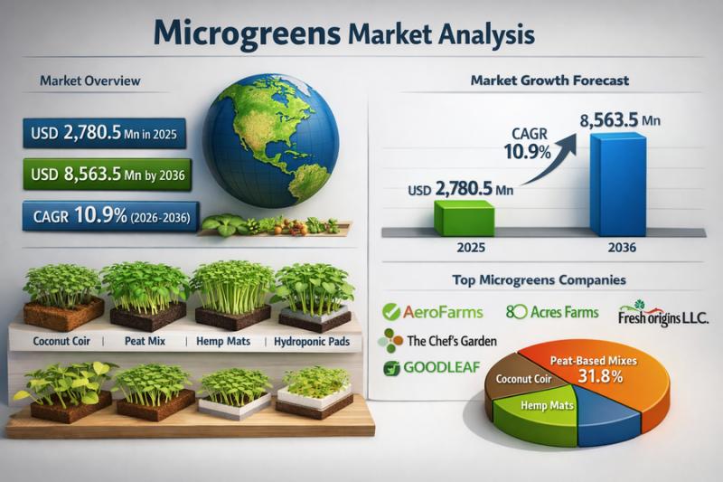
Microgreens Market to Surge at 10.9% CAGR, Set to Reach USD 8.56 Billion by 2036
The global microgreens market was valued at USD 2,780.5 million in 2025 and is projected to reach USD 8,563.5 million by 2036. Driven by rising demand for nutrient-dense foods and growing adoption across foodservice and retail channels, the industry is expected to expand at a robust CAGR of 10.9% from 2026 to 2036.
The global microgreens market represents a specialized, high-value segment within the broader fresh produce and specialty horticulture industry,…

Insomnia Supplements Market Set to Reach US$ 17.3 Bn by 2036, Growing at a Robus …
The global insomnia supplements market was valued at USD 4.7 billion in 2025 and is projected to reach USD 17.3 billion by 2036, reflecting strong growth potential. The market is anticipated to expand at a CAGR of 12.5% from 2026 to 2036, driven by rising sleep disorder prevalence, increasing consumer focus on mental wellness, and growing demand for natural and non-prescription sleep aids.
The insomnia supplements market is expected to witness…

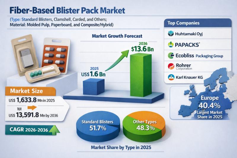
Fiber-Based Blister Pack Market Set to Surge at 21.5% CAGR Through 2036
The global fiber-based blister pack market was valued at US$ 1,633.8 million in 2025 and is projected to surge to US$ 13,591.8 million by 2036. Driven by rising demand for sustainable and eco-friendly packaging solutions, the market is expected to grow at a robust CAGR of 21.5% from 2026 to 2036.
Fiber-based blister packaging is a type of packaging that substitutes the usual plastic blister with paperboard or molded fiber components…

Psychotropic Drugs Market to Reach US$ 41.2 Bn by 2036, Growing at 5.4% CAGR
The global psychotropic drugs market was valued at USD 23.1 Bn in 2025 and is projected to reach USD 41.2 Bn by 2036. Driven by rising awareness of mental health disorders, increasing diagnosis rates, and ongoing pharmaceutical innovations, the industry is expected to grow at a CAGR of 5.4% from 2026 to 2036.
The primary drivers of the expanding psychotropic drugs market include the rising prevalence of mental disorders such as…
More Releases for Aerial
Aerial Advertising Market Is Booming Worldwide | Aerial Opportunities, Aerial Be …
The latest study released on the Global Aerial Advertising Market by AMA Research evaluates market size, trend, and forecast to 2027. The Aerial Advertising market study covers significant research data and proofs to be a handy resource document for managers, analysts, industry experts and other key people to have ready-to-access and self-analyzed study to help understand market trends, growth drivers, opportunities and upcoming challenges and about the competitors.
Key Players in…
Aerial Survey Market Trends 2022: Insight Robotics, Geosense, Blom ASA, Digital …
Aerial Survey Market research report identifies, assesses, and analyses the up-and-coming trends along with major drivers, restraints, challenges, and opportunities in the market for the IT & Telecommunication industry. The report contains estimations of CAGR values, market drivers, and market restraints about the IT & Telecommunication industry which are helpful for businesses in deciding upon numerous strategies. The market type, organization size, availability on-premises, end-users organization type, and the availability…
Aerial Survey Services Market Exceptional Business Performance | EagleView Techn …
Report Ocean recently published a new report on the Global Aerial Survey Services Market. The study has an in-depth analysis of the forecast period from 2021-2025. The report reveals a comprehensive picture of the Aerial Survey Services Market situation, taking into consideration all major trends, market dynamics, and competitive factors. Additionally, the report contains key statistics concerning the Aerial Survey Services Market situation of the leading key players, key market…
Aerial Imaging Market 2020 Outlook & Implications for Business by Eagle Aerial S …
According to a new report published by Allied Market Research, titled, "Aerial Imaging Market by Application (Geospatial Mapping, Disaster Management, Energy and Resource Management, Surveillance and Monitoring) and End User (Government, Military & defense, Energy and resource management, Agriculture & forestry, Civil engineering, Commercial, Media & entertainment) - Global Opportunity Analysis and Industry Forecast, 2020-2030." The report has offered an all-inclusive analysis of the global Aerial Imaging Market taking into…
Aerial Imaging Market - Product Experts Ideas by Blom, Eagle View Technologies, …
Asia-Pacific is projected to be the fastest growing aerial imaging markets during the forecast period due to the increase in economic growth, rapid industrialization, and growth in number of natural disasters such as landslide, earthquakes, and floods in countries such as India, China, Japan, Singapore, and others.
Schedule a Call with Our Analysts/Industry Experts To Find Solution For Your Business: https://www.alliedmarketresearch.com/connect-to-analyst/294
Blom ASA, Eagle View Technologies, Inc., Digital Aerial Solutions, LLC,…
Aerial Imaging Market - Evolution of Aerial Imaging In Coming 10 Years, Analysis …
Aerial Imaging Market 2022 - Asia-Pacific is projected to be the fastest growing aerial imaging markets during the forecast period due to the increase in economic growth, rapid industrialization, and growth in number of natural disasters such as landslide, earthquakes, and floods in countries such as India, China, Japan, Singapore, and others.
Download Report Sample (120 Pages PDF with Insights): https://www.alliedmarketresearch.com/request-sample/294
Key Findings of Aerial Imaging Market
o In 2015, government segment dominated…
