Press release
Geospatial Imagery Analytics Market Trends That Will Shape the Next Decade: Insights from Technological Advancements Revolutionizes Location Capabilities

Geospatial Imagery Analytics
How Large Will the Geospatial Imagery Analytics Market Size By 2025?
In recent times, there has been a significant augmentation in the market size of geospatial imagery analytics, which is projected to expand from $14.73 billion in 2024 to $18.49 billion in 2025, registering a compound annual growth rate (CAGR) of 25.5%. The historical growth can be associated with the increasing demand for location-oriented services, management of emergencies and disasters, progression in urban planning and development of smart cities, preservation and monitoring of the environment, and applications in defense and intelligence.
How Big Is the Geospatial Imagery Analytics Market Size Expected to Grow by 2029?
In the imminent future, the geospatial imagery analytics market is predicted to experience an unprecedented surge, catapulting to $49.61 billion by 2029, with an annual growth rate of 28.0%. This predicted expansion over the forecast period is due to a multitude of factors such as increased emphasis on climate change observation, the development of infrastructure, space tourism and exploration, worldwide connectivity initiatives, health and epidemiological research, economic progress and market insights, as well as measures against unlawful activities. The forecast period is also likely to witness significant trends such as progress in satellite technology, the emergence of cloud-based geospatial analytics platforms, the application in precision farming, city planning and intelligent cities, environmental surveillance, and climate change assessment.
View the full report here:
https://www.thebusinessresearchcompany.com/report/geospatial-imagery-analytics-global-market-report
Which Key Market Drivers Powering Geospatial Imagery Analytics Market Expansion and Growth?
The growth of the geospatial imagery analytics market is anticipated to be fueled by the escalating demand for small satellites. These satellites, weighing less than 100 kg or similar in size to suitcases, are extensively employed in imagery analytics to scrutinize tiny chunks of information around the world. They offer a more cost-effective solution while still maintaining reliable and precise results in moment-to-moment operations. An example of this was seen in September 2022. As reported by the Government Accountability Office, a governmental entity based in the US, the number of active satellites in orbit as of spring 2022 was nearly 5,500. Predictions suggest that by 2030, an additional 58,000 will be launched. Consequently, the soaring demand for small satellites is spurring the growth of the geospatial imagery analytics market.
Get your free sample here:
https://www.thebusinessresearchcompany.com/sample.aspx?id=6437&type=smp
Which Fast-Growing Trends Are Poised to Disrupt the Geospatial Imagery Analytics Market?
The surge of technological advancements is the predominant trend currently sweeping the geospatial imagery analytics market. To maintain their market standing, dominant companies within this sector are pioneering new technological developments. An example of this was seen in May 2023 when Google LLC, an American software corporation, unveiled Geospatial Creator. This sophisticated tool is intended to help developers and creators easily construct and roll-out augmented reality (AR) experiences grounded in the physical world. By utilizing ARCore and Google Maps Platform technologies, users are able to craft immersive content in a matter of minutes, bypassing the need for extensive coding expertise. The tool employs high-resolution 3D tiles that deliver a genuine depiction of the designated area, enabling creators to accurately superimpose their digital content onto the physical world.
What Are the Emerging Segments in the Geospatial Imagery Analytics Market?
The geospatial imagery analytics market covered in this report is segmented -
1) By Type: Video-Based Analytics, Imagery Analytics
2) By Geospatial Technology: Global Positioning System (GPS), Geographical Information Systems (GIS), Remote Sensing (RS), Unmanned Aerial Vehicles (UAVs)
3) By Deployment Mode: Cloud, On-Premises
4) By Organization Size: Large Enterprises, Small And Medium-Sized Enterprises (SMEs)
5) By Application: Agriculture, Mining And Manufacturing, Defense and Security, Energy, Utility, And Natural Resources, Government, Healthcare, Insurance, Other Applications
Subsegments:
1) By Video-Based Analytics: Real-time Video Processing, Object Detection And Tracking, Pattern Recognition, Event Detection
2) By Imagery Analytics: Satellite Imagery Analysis, Aerial Imagery Analysis, Drone Imagery Analysis, Multispectral And Hyperspectral Imagery Analysis
Tailor your insights and customize the full report here:
https://www.thebusinessresearchcompany.com/customise?id=6437&type=smp
Who Are the Global Leaders in the Geospatial Imagery Analytics Market?
Major companies operating in the geospatial imagery analytics market include Oracle Corporation, Hexagon AB,Environmental Systems Research Institute Inc.,TomTom NV, Trimble Inc., RMSI Private Limited,Planet Labs PBC,Maxar Technologies Holdings Inc.,L3Harris Technologies Inc., Google LLC., Zillion Info Tech Solutions Private Limited, Orbital Insight Inc., Mapidea Ltd., Satellite Imaging Corporation, Risk Management Solutions Inc., Fugro NV,onXmaps,GeoMoby,GeoMoby, Pitney Bowes Inc., AAM Pty Ltd., Critigen LLC., MDA CORPORATION LTD., PrecisionHawk Inc.,Sparkgeo Consulting Inc.
Which are the Top Profitable Regional Markets for the Geospatial Imagery Analytics Industry?
North America was the largest region in the geospatial imagery analytics market in 2024. The regions covered in the geospatial imagery analytics market report are Asia-Pacific, Western Europe, Eastern Europe, North America, South America, Middle East, Africa
Purchase the full report today:
https://www.thebusinessresearchcompany.com/purchaseoptions.aspx?id=6437
This Report Supports:
1. Business Leaders & Investors - To identify growth opportunities, assess risks, and guide strategic decisions.
2. Manufacturers & Suppliers - To understand market trends, customer demand, and competitive positioning.
3. Policy Makers & Regulators - To track industry developments and align regulatory frameworks.
4. Consultants & Analysts - To support market entry, expansion strategies, and client advisory work.
Connect with us on:
LinkedIn: https://in.linkedin.com/company/the-business-research-company,
Twitter: https://twitter.com/tbrc_info,
YouTube: https://www.youtube.com/channel/UC24_fI0rV8cR5DxlCpgmyFQ.
Contact Us
Europe: +44 207 1930 708,
Asia: +91 88972 63534,
Americas: +1 315 623 0293 or
Email: mailto:info@tbrc.info
Learn More About The Business Research Company
With over 15,000+ reports from 27 industries covering 60+ geographies, The Business Research Company has built a reputation for offering comprehensive, data-rich research and insights. Our flagship product, the Global Market Model delivers comprehensive and updated forecasts to support informed decision-making.
This release was published on openPR.
Permanent link to this press release:
Copy
Please set a link in the press area of your homepage to this press release on openPR. openPR disclaims liability for any content contained in this release.
You can edit or delete your press release Geospatial Imagery Analytics Market Trends That Will Shape the Next Decade: Insights from Technological Advancements Revolutionizes Location Capabilities here
News-ID: 4077356 • Views: …
More Releases from The Business Research Company
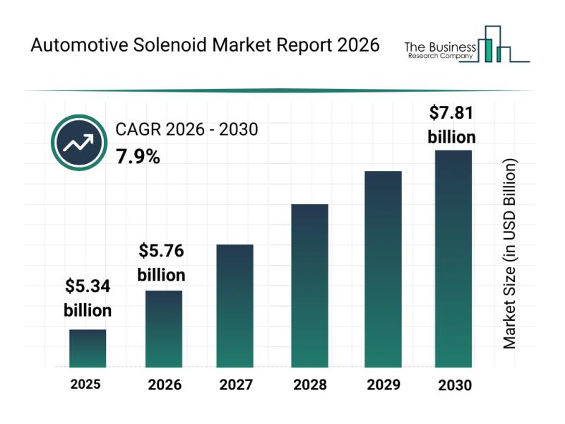
Leading Companies Fueling Growth and Innovation in the Automotive Solenoid Marke …
The automotive solenoid market is on the verge of significant expansion as advancements in technology and vehicle electrification continue to accelerate. Increasing integration of smart systems and the growing demand for efficient, eco-friendly automotive solutions are set to drive this market's development through the end of the decade.
Expected Growth Trajectory for the Automotive Solenoid Market by 2030
The automotive solenoid market is projected to reach a valuation of $7.81 billion…
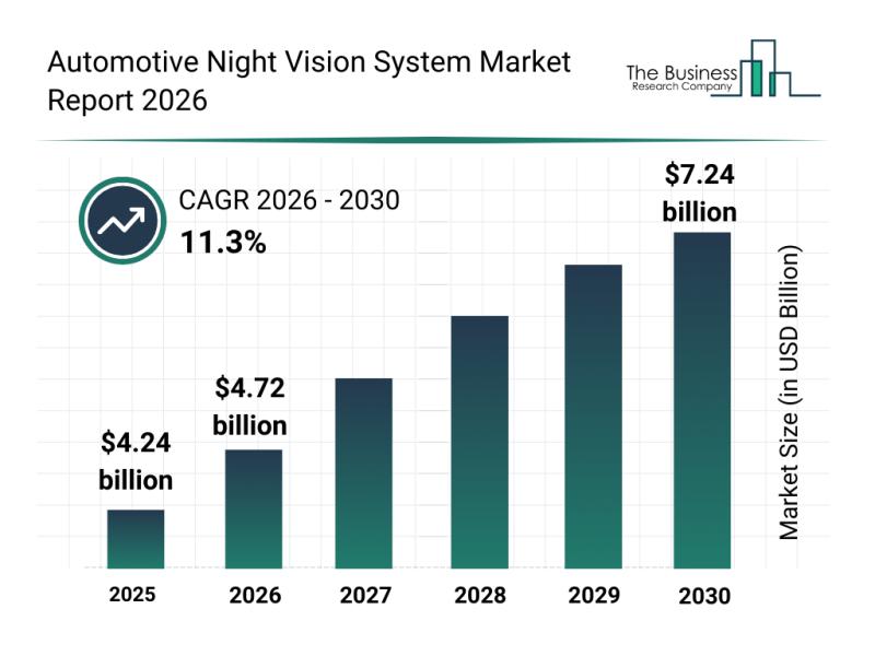
Automotive Night Vision System Market Analysis: Major Segments, Strategic Develo …
The automotive night vision system market is set to experience significant expansion over the coming years, driven by technological advancements and growing safety demands. As vehicle manufacturers continue to integrate more sophisticated safety features, this market shows promising potential for rapid growth and innovation through 2030.
Projected Expansion of the Automotive Night Vision System Market Size Through 2030
The market size for automotive night vision systems is anticipated to reach $7.24…

Segment Analysis and Major Growth Areas in the Automotive HVAC Market
The automotive HVAC market is on a trajectory of significant growth as vehicle climate control systems evolve with advanced technologies. Innovations aimed at improving energy efficiency and passenger comfort are driving the sector forward, setting the stage for substantial expansion through 2030. Let's explore the current market size, key players, influential trends, and detailed segment insights shaping this dynamic industry.
Automotive HVAC Market Size and Growth Outlook Through 2030
The automotive…

Key Strategic Developments and Emerging Changes Shaping the Automotive Electroni …
The automotive electronic controller market is on track for impressive expansion as technology continues to transform the automotive sector. With the industry embracing smarter and more connected vehicle systems, the demand for advanced controllers that manage and optimize vehicle functions is rapidly increasing. Below, we explore the market's projected growth, key players, notable trends, and the main segments shaping this dynamic field.
Projected Market Size and Growth of the Automotive Electronic…
More Releases for Imagery
OnGeo Intelligence Offers Free Satellite Imagery
OnGeo Intelligence allowing users to access free Satellite Imagery, delivering 10-meter resolution images enhanced to 2.5 meters for global locations. The service also provides high-resolution imagery to 0.3 metres - paid option. Breaking down barriers to advanced geospatial data access.
How it Works?
OnGeo Intelligence simplifies access to satellite imagery through its user-friendly platform. Users select a location and time range, and the system retrieves cloud-free images from a vast archive.…
Satellite Imagery for Precision Farming Market Utilizing Satellite Imagery for P …
The Report on "Satellite Imagery for Precision Farming Market" provides Key Benefits, Market Overview, Regional Analysis, Market Segmentation, Future Trends Upto 2030 by Infinitybusinessinsights.com. The report will assist reader with better understanding and decision making.
Market Growth of Satellite Imagery for Precision Farming Market: The Satellite Imagery for Precision Farming market is experiencing robust growth, driven by trends in high-resolution satellite imaging, AI-driven crop analysis, and the demand for sustainable agriculture…
colossis.io Revolutionizes Travel Marketing with AI-Enhanced Imagery
ALBUQUERQUE, NM, UNITED STATES, April 21, 2023
colossis.io, a leading provider of AI-enhanced travel imagery, is transforming the travel marketing industry with its cutting-edge technology. By leveraging the power of AI, colossis.io is able to elevate hotel and Airbnb photos to new heights, leaving customers in awe.
To take advantage of colossis.io's technology, all you need to do is upload your source imagery and let the AI work its magic. In just…
High-Resolution Multispectral Satellite Imagery Solutions | TELEPIX
TELEPIX provides high-resolution multispectral satellite imagery solutions to the military, intelligence, coast guard, and environment monitoring sectors. TelePIX develops these more cost-effectively than any other company by using lean procedures while maintaining quality and performance.
TelePIX High Resolution Satellite Images Product
MACC (Multi-Aperture Computational Camera)
Super-high resolution reconnaissance micro-satellite based on multi-camera synthetic aperture imaging
Captured images at LEO consists of WFOV(x1) using central camera module and NFOV(x3) using flat cameras with different LOS
MicroSat…
Outstanding Multispectral Satellite Imagery Solution | TELEPIX
TELEPIX provides outstanding multispectral satellite imagery solution in Korea. It offers a next-generation UHR (ultra-high resolution) multispectral EO/IR payload for government, military, intelligence, and space agencies.
TelePIX Multispectral Satellite Imagery
Multispectral satellites are the most affordable way to monitor any location on the planet. They beyond monitoring locations and capturing beautiful images because there is a need for actionable data to make more accurate decisions faster.
The benefits of Multispectral Imagery
Multispectral imagers are…
KOMPSAT Satellite Imagery Products | SI Imaging Services
SI Imaging Services contributes to the earth observation industry by providing very high performance remote sensing KOMPSAT satellite imagery products.
SI Imaging Services (SIIS) is a worldwide marketing and sales representative of the KOMPSAT series (KOMPSAT-3, KOMPSAT-3A and KOMPSAT-5). SIIS contributes Remote Sensing and Earth Observation industries by providing very high resolution optical and SAR images through over 160 sales partners worldwide. Customers from industries as well as government are using…
