Press release
Surging Demand For Small Satellites Powers Growth In Geospatial Imagery Analytics Market Driver: A Major Catalyst in the Evolution of the Geospatial Imagery Analytics Market in 2025

Surging Demand For Small Satellites Powers Growth
The burgeoning need for tiny satellites is anticipated to propel the growth of the geospatial imagery analytics market in the future. Small satellites, typically weighing less than 100 kg or around the size of suitcases, are employed in imagery analytics to evaluate compact pieces of global data cost-effectively, and provide more dependable and precise results in minute operations. For instance, statistics from the Government Accountability Office, an American governmental organization, showed that there were nearly 5,500 operational satellites in orbit by spring of 2022, and a prediction estimates the launch of an additional 58,000 by 2030. Consequently, this surge in demand for small satellites fuels the growth of the geospatial imagery analytics market.
Get Your Geospatial Imagery Analytics Market Report Here:
https://www.thebusinessresearchcompany.com/report/geospatial-imagery-analytics-global-market-report
What growth opportunities are expected to drive the geospatial imagery analytics market's CAGR through 2034?
The market size of geospatial imagery analytics has seen a tremendous surge in the past few years. The market, which was valued at $14.73 billion in 2024, is anticipated to grow to $18.49 billion in 2025, with a compound annual growth rate (CAGR) of 25.5%. This remarkable growth during the historic period is primarily driven by the expanding demand for location-based services, emergency management and disaster response, urban planning as well as the development of smart cities, environmental surveillance and conservation, along with defense and intelligence applications.
The market size for geospatial imagery analytics is predicted to undergo significant growth in the upcoming years, accelerating to $49.61 billion in 2029 with a compound annual growth rate (CAGR) of 28.0%. The forecasted growth can be tied to several factors such as attention to climate change monitoring, endeavors in infrastructure development, space tourism and exploration, worldwide connectivity initiatives, healthcare and epidemiological research, economic progress and market intelligence, as well as efforts to contain illegal activities. Key trends for the forecasted period are projected to be improvements in satellite technology, cloud-based geospatial analytic platforms, applications in precision farming, urban planning and development of smart cities, along with environmental surveillance and climate change study.
Get Your Free Sample Now - Explore Exclusive Market Insights:
https://www.thebusinessresearchcompany.com/sample.aspx?id=6437&type=smp
What are the emerging trends shaping the future of the geospatial imagery analytics market?
The rise of technological innovations is a predominant trend being observed in the geospatial imagery analytics market. Major enterprises in this sector are rolling out fresh technological concepts to maintain their market standing. For example, Google LLC, an American software firm, unveiled Geospatial Creator in May 2023. This potent tool enables developers and creators to construct and launch augmented reality (AR) experiences ingrained in the actual world with ease. It makes use of ARCore and Google Maps Platform technologies to allow users to generate immersive content in mere minutes, even without a large amount of coding knowledge. The tool incorporates high-quality 3D tiles that depict a true-to-life view of the chosen location. The creators can thus accurately visualize their digital content within the actual surroundings, thanks to this feature.
Which growth-oriented segments of the geospatial imagery analytics market are leading the industry's development?
The geospatial imagery analytics market covered in this report is segmented -
1) By Type: Video-Based Analytics, Imagery Analytics
2) By Geospatial Technology: Global Positioning System (GPS), Geographical Information Systems (GIS), Remote Sensing (RS), Unmanned Aerial Vehicles (UAVs)
3) By Deployment Mode: Cloud, On-Premises
4) By Organization Size: Large Enterprises, Small And Medium-Sized Enterprises (SMEs)
5) By Application: Agriculture, Mining And Manufacturing, Defense and Security, Energy, Utility, And Natural Resources, Government, Healthcare, Insurance, Other Applications
Subsegments:
1) By Video-Based Analytics: Real-time Video Processing, Object Detection And Tracking, Pattern Recognition, Event Detection
2) By Imagery Analytics: Satellite Imagery Analysis, Aerial Imagery Analysis, Drone Imagery Analysis, Multispectral And Hyperspectral Imagery Analysis
Unlock Exclusive Market Insights - Purchase Your Research Report Now!
https://www.thebusinessresearchcompany.com/purchaseoptions.aspx?id=6437
What regions are leading the charge in the geospatial imagery analytics market?
North America was the largest region in the geospatial imagery analytics market in 2024. The regions covered in the geospatial imagery analytics market report are Asia-Pacific, Western Europe, Eastern Europe, North America, South America, Middle East, Africa
What companies are at the forefront of innovation in the geospatial imagery analytics market?
Major companies operating in the geospatial imagery analytics market include Oracle Corporation, Hexagon AB,Environmental Systems Research Institute Inc.,TomTom NV, Trimble Inc., RMSI Private Limited,Planet Labs PBC,Maxar Technologies Holdings Inc.,L3Harris Technologies Inc., Google LLC., Zillion Info Tech Solutions Private Limited, Orbital Insight Inc., Mapidea Ltd., Satellite Imaging Corporation, Risk Management Solutions Inc., Fugro NV,onXmaps,GeoMoby,GeoMoby, Pitney Bowes Inc., AAM Pty Ltd., Critigen LLC., MDA CORPORATION LTD., PrecisionHawk Inc.,Sparkgeo Consulting Inc.
Customize Your Report - Get Tailored Market Insights!
https://www.thebusinessresearchcompany.com/sample.aspx?id=6437&type=smp
What Is Covered In The Geospatial Imagery Analytics Global Market Report?
•Market Size Forecast: Examine the geospatial imagery analytics market size across key regions, countries, product categories, and applications.
•Segmentation Insights: Identify and classify subsegments within the geospatial imagery analytics market for a structured understanding.
•Key Players Overview: Analyze major players in the geospatial imagery analytics market, including their market value, share, and competitive positioning.
•Growth Trends Exploration: Assess individual growth patterns and future opportunities in the geospatial imagery analytics market.
•Segment Contributions: Evaluate how different segments drive overall growth in the geospatial imagery analytics market.
•Growth Factors: Highlight key drivers and opportunities influencing the expansion of the geospatial imagery analytics market.
•Industry Challenges: Identify potential risks and obstacles affecting the geospatial imagery analytics market.
•Competitive Landscape: Review strategic developments in the geospatial imagery analytics market, including expansions, agreements, and new product launches.
Contact Us:
The Business Research Company
Europe: +44 207 1930 708
Asia: +91 88972 63534
Americas: +1 315 623 0293
Email: info@tbrc.info
Follow Us On:
LinkedIn: https://in.linkedin.com/company/the-business-research-company
Twitter: https://twitter.com/tbrc_info
YouTube: https://www.youtube.com/channel/UC24_fI0rV8cR5DxlCpgmyFQ
Learn More About The Business Research Company
With over 15000+ reports from 27 industries covering 60+ geographies, The Business Research Company has built a reputation for offering comprehensive, data-rich research and insights. Armed with 1,500,000 datasets, the optimistic contribution of in-depth secondary research, and unique insights from industry leaders, you can get the information you need to stay ahead.
Our flagship product, the Global Market Model (GMM), is a premier market intelligence platform delivering comprehensive and updated forecasts to support informed decision-making.
This release was published on openPR.
Permanent link to this press release:
Copy
Please set a link in the press area of your homepage to this press release on openPR. openPR disclaims liability for any content contained in this release.
You can edit or delete your press release Surging Demand For Small Satellites Powers Growth In Geospatial Imagery Analytics Market Driver: A Major Catalyst in the Evolution of the Geospatial Imagery Analytics Market in 2025 here
News-ID: 3882838 • Views: …
More Releases from The Business research company
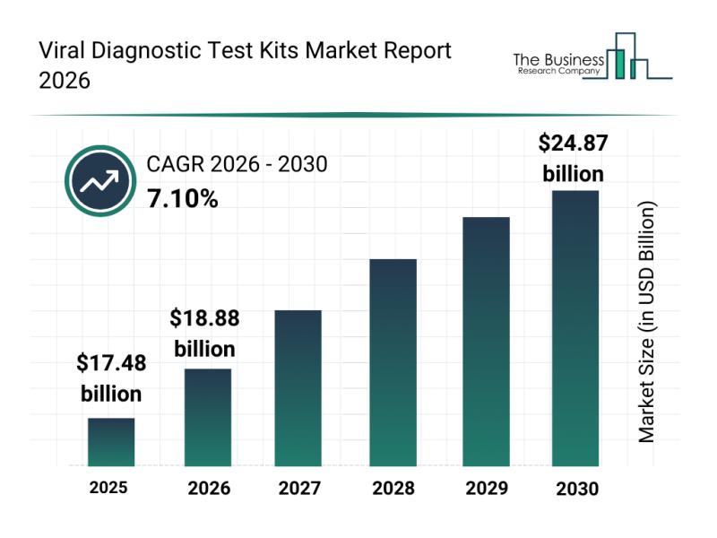
Viral Diagnostic Test Kits Market Insights Highlight Segment Expansion And Marke …
The viral diagnostic test kits market is gaining significant traction as the world focuses more on pandemic preparedness and rapid disease detection. Innovations in testing technology and a rising need for decentralized healthcare solutions are driving this sector forward. Let's explore the market size, key players, emerging trends, and segment details shaping the future of viral diagnostic testing.
Projected Market Growth for Viral Diagnostic Test Kits
The viral diagnostic test…

Vertebroplasty Needles Market Report Evaluates Growth Drivers, Challenges And Ma …
The vertebroplasty needles market is set for remarkable growth as demand for spine-related procedures rises globally. With advancements in surgical techniques and a growing elderly population, this sector is poised to expand significantly in the coming years. Let's explore the expected market size, key drivers, leading players, and segmentation details that define this evolving landscape.
Projected Market Size Growth for Vertebroplasty Needles by 2030
The vertebroplasty needles market is anticipated…

Ventricular Assist Device Market Report Provides Insights Into Market Evolution …
The ventricular assist device market is gaining significant traction as advancements in cardiovascular technology continue to evolve. Driven by demographic changes and innovations in device design, this sector is set to experience substantial growth and transformation over the coming years. Let's explore the current market size, key players, emerging trends, and detailed segment analysis that define this dynamic industry.
Projected Market Size and Growth of the Ventricular Assist Device Market …
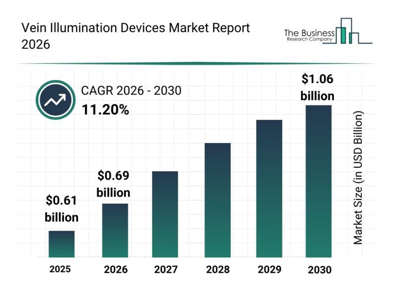
Vein Illumination Devices Market Research Explores Growth Within A $1.05 Billion …
The vein illumination devices market is poised for remarkable expansion as advancements in medical imaging technology continue to enhance patient care. With a growing focus on non-invasive procedures and improved accuracy in intravenous access, this sector is attracting significant attention from healthcare providers and technology developers alike. Below, we explore the market's valuation, key players, segmentation, and the main drivers behind its growth.
Projected Market Value and Growth of the Vein…
More Releases for Imagery
How AI Is Changing Furniture Product Imagery
Artificial intelligence is reshaping how furniture brands produce and distribute product imagery. While early AI image generation tools relied primarily on text prompts and probabilistic outputs, newer approaches in furniture visualization are increasingly built on structured 3D models. This distinction is significant. Rather than generating imagery based on interpretation alone, model-based systems create visuals that are controllable, reviewable, and repeatable. The result is not simply faster image production, but a…
OnGeo Intelligence Offers Free Satellite Imagery
OnGeo Intelligence allowing users to access free Satellite Imagery, delivering 10-meter resolution images enhanced to 2.5 meters for global locations. The service also provides high-resolution imagery to 0.3 metres - paid option. Breaking down barriers to advanced geospatial data access.
How it Works?
OnGeo Intelligence simplifies access to satellite imagery through its user-friendly platform. Users select a location and time range, and the system retrieves cloud-free images from a vast archive.…
Satellite Imagery for Precision Farming Market Utilizing Satellite Imagery for P …
The Report on "Satellite Imagery for Precision Farming Market" provides Key Benefits, Market Overview, Regional Analysis, Market Segmentation, Future Trends Upto 2030 by Infinitybusinessinsights.com. The report will assist reader with better understanding and decision making.
Market Growth of Satellite Imagery for Precision Farming Market: The Satellite Imagery for Precision Farming market is experiencing robust growth, driven by trends in high-resolution satellite imaging, AI-driven crop analysis, and the demand for sustainable agriculture…
colossis.io Revolutionizes Travel Marketing with AI-Enhanced Imagery
ALBUQUERQUE, NM, UNITED STATES, April 21, 2023
colossis.io, a leading provider of AI-enhanced travel imagery, is transforming the travel marketing industry with its cutting-edge technology. By leveraging the power of AI, colossis.io is able to elevate hotel and Airbnb photos to new heights, leaving customers in awe.
To take advantage of colossis.io's technology, all you need to do is upload your source imagery and let the AI work its magic. In just…
High-Resolution Multispectral Satellite Imagery Solutions | TELEPIX
TELEPIX provides high-resolution multispectral satellite imagery solutions to the military, intelligence, coast guard, and environment monitoring sectors. TelePIX develops these more cost-effectively than any other company by using lean procedures while maintaining quality and performance.
TelePIX High Resolution Satellite Images Product
MACC (Multi-Aperture Computational Camera)
Super-high resolution reconnaissance micro-satellite based on multi-camera synthetic aperture imaging
Captured images at LEO consists of WFOV(x1) using central camera module and NFOV(x3) using flat cameras with different LOS
MicroSat…
Outstanding Multispectral Satellite Imagery Solution | TELEPIX
TELEPIX provides outstanding multispectral satellite imagery solution in Korea. It offers a next-generation UHR (ultra-high resolution) multispectral EO/IR payload for government, military, intelligence, and space agencies.
TelePIX Multispectral Satellite Imagery
Multispectral satellites are the most affordable way to monitor any location on the planet. They beyond monitoring locations and capturing beautiful images because there is a need for actionable data to make more accurate decisions faster.
The benefits of Multispectral Imagery
Multispectral imagers are…
