Press release
LiveEO Announces Joining Esri Partner Network

Users will be able to access LiveEO's insights directly in ArcGIS.
Esri is the undisputed market leader for GIS software for utility companies in the United States and worldwide, with a particularly strong standing among forward-looking, technology oriented companies. Many utilities rely on ArcGIS to visualize and derive actionable information for their distributed assets. LiveEO has been revolutionizing the analysis of satellite data and the generation of geo-coded actionable insights on scale to optimize maintenance processes.
"We are pleased to have LiveEO join our Esri partner ecosystem as a silver partner," said Matt Piper, Global Director of Industry Solutions. "LiveEO's satellite-based infrastructure monitoring software for vegetation management and ground deformation detection is a key technology the infrastructure industry should be aware of. By aligning LiveEO's technology to the ArcGIS System, our organizations will be able to deliver actionable insights through Esri's geospatial technology, keeping our customers at the forefront of technology as they manage their assets."
Bringing the two technologies together is only a logical step to increase customer value for both solutions. The two companies are currently working on a direct integration of LiveEO's satellite-based analytics with ArcGIS enterprise and ArcGIS online and building applications with the Esri technology. Right from the start of their partnership, Esri and LiveEO started a joint go-to-market with their enhanced offering.
For more information, please get in touch with Martina Baccolo, martina@live-eo.com.
LiveEO GmbH
Gitschiner Str 94
10969 Berlin
Press contact:
Andreas Naujoks
andreas@live-eo.com
LiveEO improves lives on Earth with human-centred space data applications. By enhancing business processes by using artificial intelligence to derive actionable insights from satellite data, LiveEO contributes to increased safety, efficiency, and sustainability of maintenance operations. Today, its products are used by operators of linear infrastructure around the globe to reduce the risks of outages and disruptions. LiveEO's insights make networks more resilient against the effects of climate change and minimise the need for more carbon-intensive monitoring approaches. Its international team of around 100 employees is distributed across Berlin, New York, and Latvia.
This release was published on openPR.
Permanent link to this press release:
Copy
Please set a link in the press area of your homepage to this press release on openPR. openPR disclaims liability for any content contained in this release.
You can edit or delete your press release LiveEO Announces Joining Esri Partner Network here
News-ID: 2785991 • Views: …
More Releases from LiveEO
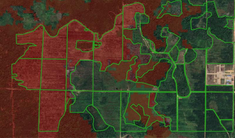
EUDR Study: Poor EU Deforestation Maps Put €133 Bn Worth of Exports at Risk
A new study conducted by LiveEO shows that supply chain disturbances amounting to €133 Billion are threatening to occur due to the low quality of open-source data sets. Plans to save cost by relying on freely available data sources in their effort to comply with the newly enacted European Deforestation Regulation (EUDR) will likely backfire economically and put the livelihoods of farmers in the global south at risk.
The EUDR aims…
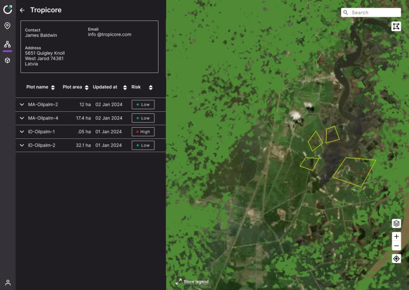
LiveEO launches free EUDR Compliance Tool, TradeAware Lite
LiveEO is excited to announce the launch of TradeAware Lite, a free version of its software solution TradeAware, designed to help companies achieve compliance with the EU Deforestation Regulation (EUDR).
Receive instant, obligation-free context on deforestation
TradeAware Lite allows users to easily input an unlimited number of geolocations from their sourcing farms and receive instant risk indications based on a smart combination of established datasets on forest cover. Getting started with…
LiveEO launches first automated EUDR Compliance Solution based on Satellite Anal …
Deforestation on our planet is advancing rapidly. Since 1990, the Earth has lost over 170 million hectares of forest area - equivalent to the size of Libya. The EU has committed itself to combating deforestation and has introduced a law requiring companies to exercise due diligence in the production of products such as palm oil, soy, coffee, and cocoa. Among other things, they must prove that their products are deforestation-free…
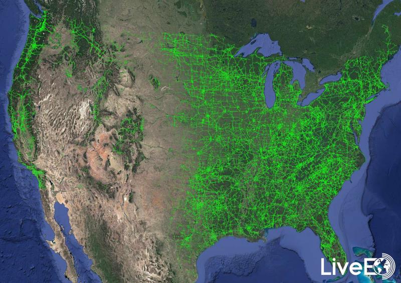
Press Release: For the first time, vegetation risk to the entire US electrical t …
Results reveal exciting insights about the vegetation condition alongside nearly 574,000 miles of overhead lines. LiveEO's further analysis helps utilities to improve management processes and to decrease wildfire and storm damage risks.
BERLIN, Germany / NEW YORK, USA - For the first time in history, vegetation encroachment risk to the entire publicly available U.S. transmission grid has been analyzed from space by the Berlin-based startup LiveEO.
The goal of this large-scale…
More Releases for GIS
Geographic Information System (GIS) Software Global Market Report 2024 - Geograp …
"The Business Research Company recently released a comprehensive report on the Global Geographic Information System (GIS) Software Market Size and Trends Analysis with Forecast 2024-2033. This latest market research report offers a wealth of valuable insights and data, including global market size, regional shares, and competitor market share. Additionally, it covers current trends, future opportunities, and essential data for success in the industry.
According to The Business Research Company's, The…
Asset Management GIS World 2024 Coverage
Several public works organizations have made a significant investment into gaining and deploying a geospatial information system (GIS) for tracking their spatial assets, maintaining historical records and sustaining a precise inventory. GIS data delivers invaluable information to these asset management organizations. Whether the user organizations have utilities, roads, parks and recreation, bridges, signals or facilities, a robust integration between asset management and GIS is integral to a long term, successful…
Integration of BIM & GIS
Building information modeling (BIM) and geographic information systems (GIS) are two technologies that have particular applications. GIS has mapping characteristics and geographical databases, while BIM is primarily utilized for building assets as an object-based information model. In challenging and extensive projects, the connecting thread between these two technologies is gaining legitimacy. BIM technologies are typically used in projects related to architecture and civil engineering, while GIS systems are typically used…
Mobile GIS Market is Anticipated to Gain Moderate CAGR by 2027 | ESRI, GIS Cloud
Mobile GIS market research analysis depicts severe economic consequences caused due to the outbreak COVID-19, which affected the entire society and world economy. Present and previous pricing structure made here helps industry players to bring the right products into the market and gain huge returns. Newly entering market player needs to take the help of this Mobile GIS market research when launching any new product. A few of the vital…
GIS Software Market 2025 by Component, Type of GIS Software, Functions, Organiza …
Increasing adoption of GIS for facilities management, integration of GIS with mainstream technologies for business intelligence, and growing demand for GIS software for smart cities development as well as urban planning have fueled the growth of the global GIS Software Market.
For Purchase Inquiry: https://www.alliedmarketresearch.com/purchase-enquiry/5259
The global GIS software market was valued at $3.24 billion in 2017 and is expected to hit $7.86 billion in 2025, registering a CAGR of 11.8% from…
Global Cloud GIS Sales Market Top player: CartoDB , ESRI , Hexagon, GIS Cloud
The report offers a comprehensive evaluation of the market. It does so via in-depth insights, understanding market evolution by tracking historical developments, and analyzing the present scenario and future projections based on optimistic and likely scenarios. Each research report serves as a repository of analysis and information for every facet of the market, including but not limited to: Regional markets, technology developments, types, applications, and the competitive landscape.
Browse Complete…
