Press release
Eye4Software B.V. Released Eye4Software GPS Toolkit version 4.0
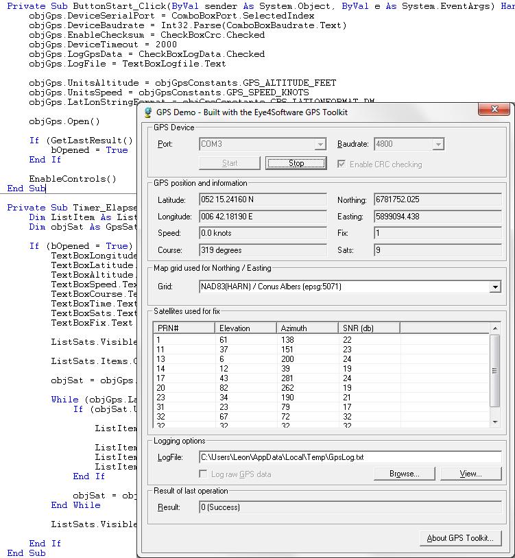
This toolkit (GPS SDK) allows software developers to add GPS and coordinate conversion functionality to their programs, websites or scripts, without any knowledge on GPS ,serial port protocols and geodesy.
Application examples include: GPS mapping, GPS navigation, GPS positioning, time synchronization, hydrographic survey, map grid transformations, map datum transformations and more.
In this latest version, the successor of version 3.2, some new features were added:
It is now possible to use NADCON, HARN/HPGN or NTv2 datum shift grid file to convert coordinates using high accuracy map datum conversions.
Also some new map projections were added, including Robinson, Eckert, van der Grinten, Winkel and Equidistant Conic projection.
The internal database has been updated, and now contains more then 500 map datums and more then 5000 local map grids.
The package is shipped containing two ActiveX controls, one supporting 32 bit Windows platforms, and a second one that can be used to write GPS applications on 64 bit Windows platforms.
The toolkit can be used from various programming, web and scripting environments, including: VBScript, Visual Basic, Visual C++, Visual C# .Net, Visual Basic.Net, Borland Delphi, Borland C++ builder, PHP, ASP and ASP.Net.
For more information about this product, please visit the product’s website at http://www.eye4software.com/products/gpstoolkit
Eye4Software B.V. is manufacturer of value for money GPS related software products.
Please check their website at http://www.eye4software.com for more information.
Eye4Software B.V.
De Regge 11
7491MC Delden
The Netherlands
http://www.eye4software.com
This release was published on openPR.
Permanent link to this press release:
Copy
Please set a link in the press area of your homepage to this press release on openPR. openPR disclaims liability for any content contained in this release.
You can edit or delete your press release Eye4Software B.V. Released Eye4Software GPS Toolkit version 4.0 here
News-ID: 211058 • Views: …
More Releases from Eye4Software B.V.
Eye4Software Released Hydromagic version 5.0 hydrographic software
Today, Eye4Software B.V. is proud to announce, that the latest version of their Hydrographic Survey Software, Hydromagic version 5.0 has been released to the public.
The main purpose of this software is to map the bottom of a river or ocean, by using a GPS or RTK positioning system combined with a singlebeam fishfinder or echosounder.
Once the data acquisition has been completed, the sounding can, if needed, be filtered and corrected…
More Releases for GPS
Furthrive GPS Review: The Best GPS Collar of 2025
Losing a pet can be heartbreaking, and traditional fences do not always keep curious dogs or cats safe during walks, hikes or backyard play. Furthrive GPS changes that with a smart collar system that tracks location in real time and sets invisible boundaries to prevent escapes. This review breaks down how the device works, what pet owners gain from it, and whether it lives up to the promise of simple,…
GPS Market Potential Surge Evaluating GPS Market Growth Opportunities Ahead - 20 …
In recent years, the global GPS Market has witnessed a dynamic shift, influenced by changing consumer preferences, technological advancements, and a growing emphasis on sustainability. The Research report on GPS Market presents a complete judgment of the market through strategic insights on future trends, growth factors, supplier landscape, demand landscape, Y-o-Y growth rate, CAGR, pricing analysis. It also provides and a lot of business matrices including Porters Five Forces Analysis,…
AirBolt GPS Tracker Reviews USA: Is AirBolt GPS Tracker The World's Smartest GPS …
AirBolt GPS Tracker Reviews USA: Is AirBolt GPS Tracker The World's Smartest GPS Tracker? All You Need To Know About AirBolt GPS Tracker Before You Buy.
Looking for a game-changer in the realm of GPS trackers? Enter the AirBolt GPS, a revolutionary device that transcends the limitations of traditional Bluetooth trackers and bulky GPS units. Boasting four years of dedicated refinement, AirBolt presents a masterpiece of technology that redefines tracking…
Global GPS Equipment Market | Global GPS Equipment Industry | Global GPS Equipme …
GPS or Global Positioning System equipment is used to find the real-time location-based accurate information of any vehicle, or other types of assets. GPS detects the person or vehicle that uses the GPS to track its exact location. The location information is stored & transmitted to others, which are connected by the internet using radio, cellular, or satellite modem embedded in the unit. It comprises a GPS module for receiving…
Global GPS Equipment Market | Global GPS Equipment Industry | GPS Equipment Mark …
Global Positioning System or GPS equipment market comprises of sales of global positioning systems equipment & related services to determine the ground position of an object through GPS satellites. It is a satellite navigation system that transmits accurate signals that allow GPS equipment to decode or measure the desired location of the satellite. These equipments are smaller in size. With the advent of technologies, it has been possible to develop…
Global GPS Fleet Tracking System Market 2020 Industry Analysis by Manufacturers …
The market research report entitled Global GPS Fleet Tracking System Market 2020 by Company, Type and Application, Forecast to 2025 provides analysis on market conditions, trends, capability, key players, opportunities, and geographical analysis. The report proves to be an ultimate solution when it comes to a better understanding of the industry and leads the business growth. The report covers an overview of the segments and sub-segmentations including the product types,…
