Press release
“Toward a National Cartography: American Mapmaking, 1782-1800”
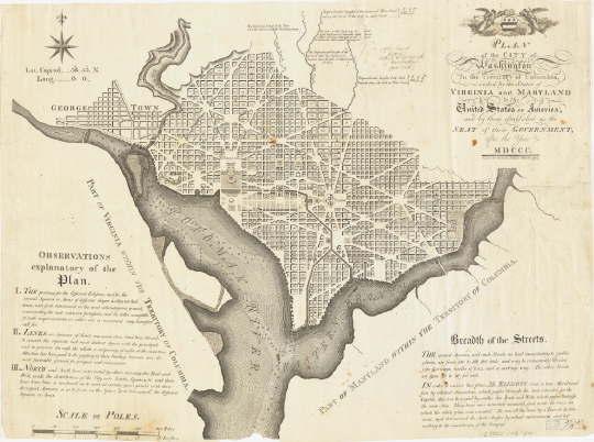
Andrew Ellicott, Plan of the City of Washington in the Territory of Columbia. Philadelphia, 1792. Image courtesy of Harvard Map
Exhibition curator Michael Buehler of Boston Rare Maps originally assembled this lineup of rare and unusual maps for display at the Harvard Map Collection, and now offers the digital collection to viewers around the world. Buehler is a long-time collector of rare maps and historical ephemera, is a regular public speaker on the subject and has published numerous articles on The Portolan, the journal of the Washington Map Society. For additional information on Michael Buehler or Boston Rare Maps, please visit www.BostonRareMaps.com.
Highlighting this unique exhibition is a 1792 plan for “The city of Washington in the Territory of Columbia”, now Washington D.C., by surveyor Andrew Ellicott. The plan depicts a grand capital on the European model, with broad avenues, large public squares and dramatic sightlines. Its unstated intent was to convey the grandeur and permanence of the national government – which at the time was only three years old, boasted a bureaucracy of fewer than 200 employees and rested on a Constitution that was feared as much as it was venerated.
The exhibition also tracks urban development in the Northeast with Osgood Carleton’s “Accurate Plan of the Town of Boston”, published in May of 1797. Carleton’s plan of Boston was the largest and most accurate map of the town published to date. It was based primarily on a survey he conducted “by order of the General Court,” as part of a state mapping project begun in 1794. This was one of the last significant maps of Boston before the great land-making projects of the 19th century, which created the Back Bay. Noteworthy landmarks include the new State House on Beacon Hill (on land that once belonged to John Hancock), as well as the Charles River and West Boston Bridges.
American expansion is also chronicled and can be seen in John Fitch’s “Map of the North West Parts of the United States of America,” published in 1785. Fitch, a mapmaker and surveyor who went on to invent the steamboat, compiled this map primarily from William McMurray’s map of the United States, along with information from his own surveys. Fitch engraved the map himself and printed it on a press of his own construction. Like McMurray’s map, which is also included in the exhibition, Fitch depicted the Old Northwest carved into ten proto-states as specified by the Land Ordinance of 1784.
Additional featured works include maps of New England, Massachusetts, New York, Baltimore, North Carolina and beyond by prominent mapmakers like Dennis Griffith, Jonathan Price, Phinehas Merrill, Matthew Clark, John Norman and many others. In addition to city plans and maps, the exhibition also includes antique postal and road maps, navigational charts, and numerous additional cartographical specimens from post-Revolution America.
Editor’s Note: • Background and additional digital color images available.
• Support for feature development on rare maps available.
• Interviews with gallery owner Michael Buehler are encouraged.
About Boston Rare Maps
Boston Rare Maps specializes in rare and unusual antique and vintage maps depicting all periods of American history. They offer American historical prints, city views and a growing selection of illustrated broadsides. They also serve a wide variety of clients, including private collectors and institutional map collections, as well as those seeking just a few special pieces for themselves or as gifts to clients, friends or family.
Joshua Payne
info@fuscofour.com
617 363-0405
8 Allenwood Street
West Roxbury, MA 02132
This release was published on openPR.
Permanent link to this press release:
Copy
Please set a link in the press area of your homepage to this press release on openPR. openPR disclaims liability for any content contained in this release.
You can edit or delete your press release “Toward a National Cartography: American Mapmaking, 1782-1800” here
News-ID: 195109 • Views: …
More Releases for Map
Map It Media, Putting Businesses On The Map
Image: https://www.getnews.info/wp-content/uploads/2024/08/1724359984.png
Map It Media: Your Go-To Full-Service Business Solution
In today's fast-paced digital landscape, businesses of all sizes are constantly seeking ways to enhance their online presence and streamline operations. Enter Map It Media, a full-service business solution that caters to the needs of both small businesses and large enterprises alike. With a mission to "put you on the map," Map It Media offers a comprehensive suite of services designed to…
Digital Map Market Still Has Room to Grow | Emerging Players Google, Digital Map …
Global Digital Map Market Report from AMA Research highlights deep analysis on market characteristics, sizing, estimates and growth by segmentation, regional breakdowns & country along with competitive landscape, player's market shares, and strategies that are key in the market. The exploration provides a 360° view and insights, highlighting major outcomes of the industry. These insights help the business decision-makers to formulate better business plans and make informed decisions to improved…
Digital Map Market Revenue, Facts, Statastics By DigitalGlobe, Digital Map Produ …
Digital Map Market research report is a resource that makes available current as well as upcoming technical and financial details of the industry. The report not only takes into consideration all the market drivers and restraints which are derived from SWOT analysis but also gives all the CAGR projections for the historic year 2018, base year 2019 and forecast period. This industry analysis report speaks in detail about the manufacturing process,…
Digital Map Market 2019 Precise Outlook –Magellan, Yahoo, Automotive Navigatio …
The Digital Map Market report is a compilation of first-hand information, qualitative and quantitative assessment by industry analysts, inputs from industry experts and industry participants across the value chain. The report provides in-depth analysis of parent market trends, macro-economic indicators and governing factors along with market attractiveness as per segments. The report also maps the qualitative impact of various market factors on market segments and geographies.
Get Sample Copy of this…
Digital Map Market : A Well-Defined Technological Growth Map With An Impact Anal …
GLOBAL DIGITAL MAP MARKET SIZE, STATUS AND FORECAST 2020-2026
The report provides a unique tool for evaluating the Digital Map Market, highlighting opportunities, and supporting strategic and tactical decision-making. This report recognizes that in this rapidly-evolving and competitive environment, up-to-date marketing information is essential to monitor performance and make critical decisions for growth and profitability. It provides information on trends to identify emerging technologies and developments, and focuses on markets capacities…
Digital Map Market Outlook to 2027 - ESRI, TOMTOM, Google, Mapbox, Digital Map P …
An off-the-shelf report on Digital Map Market which has been compiled after an in-depth analysis of the market trends prevailing across five geographies (North America, Europe, Asia-Pacific, Middle-East and Africa, and South America). Various segments of the market such as type/components/ application/industry verticals/ end-users are analyzed with robust research methodology which includes three step process starting with extensive secondary research to gather data from company profiles, global/regional associations, trade journals,…
