Press release
Drones & Satellites: FuVeX and LiveEO Demonstrate Tech Complementation for Vegetation Management and Powerline Inspection

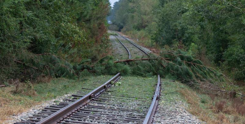
Satellites detect Trees, Drones capture details
To bring together the best of both worlds was the project’s goal. Drones and satellites both look at things from above, though from quite different altitudes. For the use case of utility vegetation management and inspection, this results in different strengths for either technology. While satellites can capture imagery covering the entire network almost instantaneously, drones deliver highly detailed imagery of particular areas of interest.
Developing a drone integration into the existing vegetation management solution of LiveEO harnesses the advantages of both technologies. At the same time, the complementary approach brings with it none of the drawbacks of the still predominant approach to vegetation monitoring, crewed helicopters, and manual inspections. These traditional methods are not only inefficient with a long turnaround but also extremely costly. Using the drone satellite combination, an estimated 90% in cost savings for line inspections is feasible.
FuVeX’s drones are especially well-suited for this type of operation. They have ranges of up to 40 km; their patented technology provides them with stability in windy weather. Also, FuVeX has received the first authorization in Spain to perform Beyond Visual Line Of Sight drone operations over powerlines. “At FuVeX, we are working to fully automate powerline inspections using long-range drones. For us, it is a pleasure to collaborate with other companies like LiveEO to disrupt the utility management sector”, states Carlos Matilla, co-founder and CEO of FuVeX.
LiveEO’s market-leading satellite-based vegetation management solution is in use with electric utilities around the globe. The accuracy provided by high-resolution satellite imagery has proven to be sufficient for most applications. However, for particularly risky or highly regulated segments, some utilities still resort to other inspection methods. “It is great to demonstrate that our solution can generate insights not only from satellite data, for which it was originally designed, but can integrate other data sources, too. What matters to us eventually is value for our customers – and here we see potential that we will continue to explore”, concludes Daniel Seidel, Co-CEO and Co-Founder of LiveEO.
LiveEO GmbH
Glitschiner Straße 94
10969 Berlin
Andreas Naujoks, PR Manager
andreas@live-eo.com
LiveEO is bringing Earth Observation to enterprise customers starting in the infrastructure sector. LiveEO utilizes satellite technology to monitor large infrastructure networks globally and empowers the operators to save operational expenses by observing dangers from external threats. By using AI the start-up is generating overviews of thousands of kilometers for decisions on the management level as well as information for the worker on the ground via a front-end and mobile app. LiveEO’s goal is to monitor every major infrastructure grid until 2025. The company has around 50 employees and is headquartered in Berlin, Germany.
This release was published on openPR.
Permanent link to this press release:
Copy
Please set a link in the press area of your homepage to this press release on openPR. openPR disclaims liability for any content contained in this release.
You can edit or delete your press release Drones & Satellites: FuVeX and LiveEO Demonstrate Tech Complementation for Vegetation Management and Powerline Inspection here
News-ID: 2374250 • Views: …
More Releases from LiveEO GmbH

The UVM Podcast Wins Utility Arborist Association Award For Education
The UVM Podcast, launched in 2021, is the original, award-winning and CEU-accredited podcast that focuses on preventing contact between trees and lines, on enhancing the reliability and safety of the world's electric grid. Co-hosted by Steve Cieslewicz, Principal Investigator of the 2003 NE Blackout, and Nick Ferguson, a UVM Technology Leader, The UVM Podcast was this week the recipient of the Utility Arborist Association (UAA) prize for education. The UVM…
LiveEO announces Rapid Response Insights for Storm Damage
LiveEO will be showcasing their newest product at InnoTrans 2022. An automated rapid response solution based on radar satellite data, Rapid Response Insights works in all weather conditions, pinpointing storm damage locations within hours, so infrastructure operators can restore service without delay.
Fallen trees across rail tracks or downed power lines are dangerous and costly for operators of railways and other linear infrastructure. They can lead to lengthy service interruptions, or…
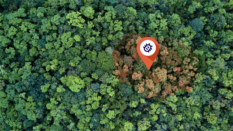
Satellite Analytics Solution for early Bark Beetle Detection Announced
Managing and monitoring forests is challenging. They typically cover vast areas while problems like bug infestations occur locally, with devastating effects to the ecosystem and economic damage to the owners. Satellite analytics and solutions company LiveEO today announced a product based on satellite data and AI that enables forest owners to mitigate those risks.
Recent increases in wood prices that trickled down to countless other industries showed the significance of wood…

LiveEO Invites Industry to Join New Partner Program
The leading provider of satellite-based analytics and solutions for infrastructure operators, LiveEO, launches a new partnership program designed to give different types of partners the right framework to bring the best solutions, technologies, services to market, and support a growing customer base.
When companies join forces, more is possible. Since LiveEO's inception in 2018, the company has forged strong partnerships with players like enterprise software giant SAP, satellite data provider…
More Releases for Drones
RC Drones Market is Booming Worldwide with DJI, Parrot Drones SAS, Walkera
Latest Research Study on Global RC Drones Market published by AMA, offers a detailed overview of the factors influencing the global business scope. Global RC Drones Market research report shows the latest market insights with upcoming trends and breakdown of the products and services. The report provides key statistics on the market status, size, share, growth factors, Challenges and Current Scenario Analysis of the Global RC Drones. This Report also…
Construction Drones Market Outlook to 2027 by Crucial Players - 3DR, ABJ Drones, …
Drones are also known as UAV (unmanned aerial vehicles), and operate on energy sources like batteries. The rising demand for drones from construction to capture high-resolution images and inspection which anticipating the growth of the construction drones market. Drone facilitates better site monitoring, measuring dimensions of roads and structures, interpreting images, and maps for better communication. Also, it is used to capture infrared images, thermal censored images, night vision images,…
Commercial Drones Market By Type (Fixed Wing Drones, Rotary Bade Drones, Hybrid …
Aircrafts that have the capability to fly autonomously with the help of an embedded program or which can be remotely operated from ground by a pilot are called as drones. Commercial drones are unmanned aerial aircrafts that are designed for commercial applications such as risk mitigation, resource planning, research & excavation, urban planning, engineering, farming management, tourism, aerial imaging, LiDAR applications, cargo management, weather monitoring, traffic control, green mapping, and…
Consumer Drones to Continue their Dominance in Global Drones Market: TechSci Res …
Rising demand from commercial and military applications along with emergence of technologically advanced drones to aid growth of global drones market through 2023
According to TechSci Research report, “Global Drones Market By Type, By Segment, By Application, By Payload, By Region, Competition Forecast & Opportunities, 2023”, the global drones market is projected to cross $ 141 billion by 2023. The growth in the market is led by emergence of technologically advanced…
Global Nano Drones Market 2018-2025 | Advance Technology, Future Guidelines, Stu …
The recently published report titled Global Nano Drones Industry 2018 Market Research Report is an in depth study providing complete analysis of the industry for the period 2018 – 2025. It provides complete overview of Global Nano Drones Market considering all the major industry trends, market dynamics and competitive scenario.
The Global Nano Drones Industry Report 2018 is an in depth study analyzing the current state of the Global Nano Drones…
Photography Drones Market Report 2018: Segmentation by Type (3-rotor Drones, 4-r …
Global Photography Drones market research report provides company profile for Parrot, AEE, AirDog, DJI, Autel Robotics, Yuneec and Others.
This market study includes data about consumer perspective, comprehensive analysis, statistics, market share, company performances (Stocks), historical analysis 2012 to 2017, market forecast 2018 to 2025 in terms of volume, revenue, YOY growth rate, and CAGR for the year 2018 to 2025, etc. The report also provides detailed segmentation on the…