Press release
Eye4Software B.V. Releases GPS Mapping Studio Software
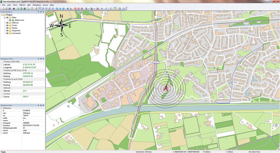
The purpose of the software is to display your current position on digital maps in real time.
You can record all movements to a file for later analysis or for instance, to keep track of the covered survey area.
The software can also be used to import- and export, view, edit and convert maps. The software supports 40 of the most used map formats around, such as Arc/Info formats, CAD formats like DXF and DGN, Nautical Chart formats like BSB and S57, SRTM and ACE2 elevation files, ESRI shapefiles, USGS DLG files, binary grid files, image files and many more.
It is shipped with a large database containing over 3500 map projections, allowing it to be used anywhere on the globe. Also map datum correction grids, like NADCON, HARN/HPGN and NTv2, are supported.
The minimum requirement to use this software is a desktop, notebook or netbook running Windows XP SP2 or higher. To use the software for realtime navigation and position tracking, also a NMEA0183 compatible GPS receiver is required.
Please visit our product page at http://www.eye4software.com/products/gpsmapping for more information about this product, or to download a fully functional 30 day trial version for free.
Eye4Software B.V. is the developer of value for money GPS software products like GPS developer components, coordinate conversion tools and GPS/GIS mapping solutions.
Leon Steijger
De Regge 11
7491MC Delden
The Netherlands
This release was published on openPR.
Permanent link to this press release:
Copy
Please set a link in the press area of your homepage to this press release on openPR. openPR disclaims liability for any content contained in this release.
You can edit or delete your press release Eye4Software B.V. Releases GPS Mapping Studio Software here
News-ID: 202327 • Views: …
More Releases from Eye4Software B.V.
Eye4Software Released Hydromagic version 5.0 hydrographic software
Today, Eye4Software B.V. is proud to announce, that the latest version of their Hydrographic Survey Software, Hydromagic version 5.0 has been released to the public.
The main purpose of this software is to map the bottom of a river or ocean, by using a GPS or RTK positioning system combined with a singlebeam fishfinder or echosounder.
Once the data acquisition has been completed, the sounding can, if needed, be filtered and corrected…
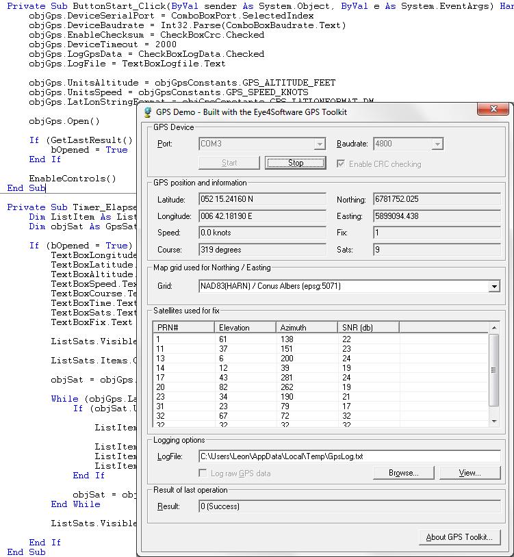
Eye4Software B.V. Released Eye4Software GPS Toolkit version 4.0
Today Eye4Software B.V. released version 4.0 of their GPS Toolkit for Windows.
This toolkit (GPS SDK) allows software developers to add GPS and coordinate conversion functionality to their programs, websites or scripts, without any knowledge on GPS ,serial port protocols and geodesy.
Application examples include: GPS mapping, GPS navigation, GPS positioning, time synchronization, hydrographic survey, map grid transformations, map datum transformations and more.
In this latest version, the successor of version…
More Releases for GPS
Global GPS Equipment Market | Global GPS Equipment Industry | Global GPS Equipme …
GPS or Global Positioning System equipment is used to find the real-time location-based accurate information of any vehicle, or other types of assets. GPS detects the person or vehicle that uses the GPS to track its exact location. The location information is stored & transmitted to others, which are connected by the internet using radio, cellular, or satellite modem embedded in the unit. It comprises a GPS module for receiving…
Global GPS Equipment Market | Global GPS Equipment Industry | GPS Equipment Mark …
Global Positioning System or GPS equipment market comprises of sales of global positioning systems equipment & related services to determine the ground position of an object through GPS satellites. It is a satellite navigation system that transmits accurate signals that allow GPS equipment to decode or measure the desired location of the satellite. These equipments are smaller in size. With the advent of technologies, it has been possible to develop…
Global GPS Fleet Tracking System Market 2020 Industry Analysis by Manufacturers …
The market research report entitled Global GPS Fleet Tracking System Market 2020 by Company, Type and Application, Forecast to 2025 provides analysis on market conditions, trends, capability, key players, opportunities, and geographical analysis. The report proves to be an ultimate solution when it comes to a better understanding of the industry and leads the business growth. The report covers an overview of the segments and sub-segmentations including the product types,…
GPS Market analysis report- with Leading players and Major Applications: GPS-Ena …
GPS Market
Worldwide Market Reports has announced the addition of the “Global GPS Market Size, Status and Forecast 2019-2025”, The report classifies the global Market in a precise manner to offer detailed insights about the aspects responsible for augmenting as well as restraining market growth.
Global positioning system (GPS) is a global navigation satellite system that provides information about time and geolocation to the receiver anywhere on or near the earth where four…
Location Based Services Market Report 2018: Segmentation by Component (Hardware, …
Global Location Based Services market research report provides company profile for Cisco Systems, Inc., Google Inc., Alcatel-Lucent SA, AT&T Inc., International Business Machines Corporation, Ltd., Qualcomm Inc., Microsoft Corporation, Oracle Corporation, Apple, Inc., and Bharti Airtel, LTD. and Others.
This market study includes data about consumer perspective, comprehensive analysis, statistics, market share, company performances (Stocks), historical analysis 2012 to 2017, market forecast 2018 to 2025 in terms of volume, revenue,…
GPS Tracking Device Market - Increased Accuracy Of GPS And Decreased In Cost Of …
Navigators and security systems have always been a necessity things of human’s life. The developments of advanced electronics have brought revolutionary changes in these fields. The GPS tracking devices are an electronic device used for tracking location of devices. Most of the tracking systems use GPS module to find out the device position. Many systems also combine communication components such as satellite transmitters to communicate the device location to a…