Press release
Use of GIS in Developing Transportation Decision Support System
In the past, the construction plans in Taiwan were drawn up and submitted to Executive Yuan by individual executives based on their business accountabilities, and then deliberated by Executive Yuan. However, due to the fiscal restriction, Executive Yuan considers the construction plans seriously, especially when the need of analyzing competition among each construction plan increases day by day.
In order to facilitate the development of transportation system and make efficient resource allocation, Institute of Transportation, Ministry of Transportation and Communications (MOTC) utilized GIS technologies to assist Taiwan transportation executive in completing public construction, formulating feasible plans, and analyzing critical issues in transport services.
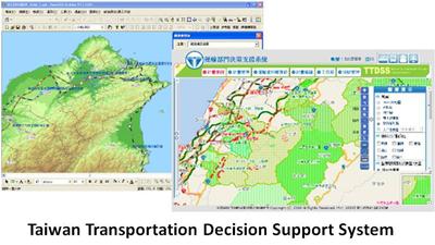
Developed by Institute of Transportation, MOTC, Taiwan Transportation Decision Support System (TTDSS) fully integrates multiple databases and map data to perform map display and analysis functions, helping the commissioners to make better policies and decisions when developing Taiwan transportation system.
With the aim of integrating databases and displaying relevant maps of transportation, TTDSS employed SuperWebGIS 3 to display, operate and analyze maps, allowing the commissioners to view and manipulate map data over the Internet. Moreover, SuperGIS Desktop 3.1 also allows the administrators of TTDSS to modify map content efficiently and facilitate map output with the custom functions.
Due to the development of TTDSS, commissioners of Taiwan transportation executive now can display diverse theme maps and data on-line and implement various analysis functions to reach fateful government decisions. Also, the efficiency of plan scrutinizing is greatly improved, allowing the commissioners to make decision more objectively and effectively.
For more information about the application story, please visit http://www.supergeotek.com/Library_2_201302.aspx
For more product information about SuperGIS software, please visit http://www.supergeotek.com/products_all_product_list.aspx
Supergeo Technologies Inc. is a leading global provider of GIS software and solutions. Since the establishment, Supergeo has been dedicated to providing state-of-the-art geospatial technologies and comprehensive services for customers around the world. It is our vision to help users utilize geospatial technologies to create a better world.
Supergeo software and applications have been spread over the world to be the backbone of the world’s mapping and spatial analysis. Supergeo is the professional GIS vendor, providing GIS-related users with complete GIS solutions for desktop, mobile, server, and Internet platforms.
2F., No. 324, Sec. 1, Neihu Road, Taipei, 114, TAIWAN, R.O.C.
TEL:886226591899
Website: http://www.supergeotek.com
Email: angela@supergeotek.com
This release was published on openPR.
Permanent link to this press release:
Copy
Please set a link in the press area of your homepage to this press release on openPR. openPR disclaims liability for any content contained in this release.
You can edit or delete your press release Use of GIS in Developing Transportation Decision Support System here
News-ID: 252592 • Views: …
More Releases for GIS
Mobile GIS Market is Anticipated to Gain Moderate CAGR by 2027 | ESRI, GIS Cloud
Mobile GIS market research analysis depicts severe economic consequences caused due to the outbreak COVID-19, which affected the entire society and world economy. Present and previous pricing structure made here helps industry players to bring the right products into the market and gain huge returns. Newly entering market player needs to take the help of this Mobile GIS market research when launching any new product. A few of the vital…
GIS Software Market 2025 by Component, Type of GIS Software, Functions, Organiza …
Increasing adoption of GIS for facilities management, integration of GIS with mainstream technologies for business intelligence, and growing demand for GIS software for smart cities development as well as urban planning have fueled the growth of the global GIS Software Market.
For Purchase Inquiry: https://www.alliedmarketresearch.com/purchase-enquiry/5259
The global GIS software market was valued at $3.24 billion in 2017 and is expected to hit $7.86 billion in 2025, registering a CAGR of 11.8% from…
Geographic Information System Market (GIS) 2019 Global Analysis by Top Industry …
Global Geographic Information System Market 2019-2024 Research Report is an exhaustive study on the present industry scenario of the Global Geographic Information System market with a special focus on the industry and growth of the market. The Geographic Information System Market revenue was xx.xx Million USD in 2014, grew to xx.xx Million USD in 2018, and will reach xx.xx Million USD in 2024, with a CAGR of x.x% during 2019-2024.…
Global Cloud GIS Market 2017: SuperMap, GeoStar, Google Maps (Google), Bing Maps …
Global Cloud GIS Market Report 2017-2022
Industry research report that focuses on Cloud GIS Market and provides in-depth Global Cloud GIS market analysis and future prospects of Cloud GIS market 2017-2022 analyses the crucial factors of the Cloud GIS market based on current industry conditions, market trends & demands, business methods embraced by Cloud GIS market contenders and their growth scenario. This report also provides in-depth data of Cloud GIS…
Global Geographic Information System (GIS Software) Market 2017: Hexagon, Pitney …
The research Report titled Global Geographic Information System (GIS Software) market is an in-depth and a professional document that provides a comprehensive overview and depth perception of the key regional market standing of the Geographic Information System (GIS Software) trade on an global level that especially focuses on the core regions such as North & South America, Europe, Africa, South & Middle East Asia and Australia and also the key…
Global Cloud GIS Market 2017-2022 Carto DB, ESRI, Hexagon, GIS Cloud, Mapbox
Cloud GIS Market Research Report
A market study ” Global Cloud GIS Market ” examines the performance of the Cloud GIS market Size 2017. It encloses an in-depth Research of the Cloud GIS market state and the competitive landscape globally. This report analyzes the potential of Cloud GIS market in the present and the future prospects from various angles in detail.
Request For Sample Report: http://bit.ly/2hgrZNQ
The Global Cloud GIS Market 2017…