Press release
New Possibilities in Digitizing Aerial Images - Enhance Safety and Usability of Valuable Archive Material
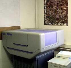
Scanner for aerial images
What does that mean? Scanning your archive of aerial images (or scanning it anew) opens up a whole range of possibilities. Images are digitized with an incredibly high resolution which was not available before. They can be evaluated with nowadays cutting edge software solutions to produce valuable 2D and 3D vector data even from historical images. Digital ortho images can be re-produced with a much higher resolution than what possible in the past and become available for a multitude of visualizations or evaluations. Images can now be accessed in a GIS database instead of having to look through many shelves with heavy film. They can easily be copied and secured on data carriers to prevent the loss of valuable imagery for instance in case of accidents or fire.
GTA Geoinformatik GmbH offers professional digitizing services with the high resolution precision scanner DSW 700™ (Leica Geosystems) at very competitive prices. The scanner uses a CCD camera that has a CCD sensing area of 4000 x 2700 pixels, handling cut film as well as roll film. With a geometrical precision of 1.5 µm per axis the scanner works with aerial images (color, color infrared, black and white, positive and negative) with a maximum size of 260 x 260 mm. Available data formats are VITec, Sun Raster, plain raster, TIFF, tiled TIFF, NITF, JPG2000.
GTA, founded in 1991 as geoinformatics and photogrammetry company with its main office in Neubrandenburg, Germany, is one of the leading developers and producers in the 3D geodata sector. The tridicon® software solution offers modules for the automatic generation and texturing of 3D city models and different solutions for the generation of almost any level of detail of a 3D city model.
The GTA scanning service offers more than 10 years experience in handling valuable aerial imagery of many satisfied customers as well as high-tech hardware and software equipment.
GTA Geoinformatik GmbH
Managing director: Dr. Peter Lieckfeldt
Lindenstraße 63, D-17033 Neubrandenburg
Phone: +49 395 3581 142
Fax: +49 395 3684 424
Email: contact@tridicon.de
Internet: www.gta-geo.de
www.tridicon.de
Marketing contact: Kathrin Hutton
hutton@gta-geo.de, Phone +49 395 3581 238
This release was published on openPR.
Permanent link to this press release:
Copy
Please set a link in the press area of your homepage to this press release on openPR. openPR disclaims liability for any content contained in this release.
You can edit or delete your press release New Possibilities in Digitizing Aerial Images - Enhance Safety and Usability of Valuable Archive Material here
News-ID: 209229 • Views: …
More Releases from GTA Geoinformatik GmbH
New Software Solution for Automatic Point Cloud Generation and 3D Modelling from …
GTA Geoinformatik GmbH presents new 3D software solutions at COM.GEO 2012 in Washington D.C.
Fully automated generation of very dense 3D point clouds and Digital Surface Models (DSM) from stereo aerial images (nadir and oblique) seems to become more and more important. Most efficiently this is done using semi global matching (SGM) algorithms. With the software release tridicon® PointCloud GTA offers a new tool that produces accurate point clouds for…

Breakthrough in Automatic Analysis of Aerial Images with Computer Stereo Vision
GTA Geoinformatik GmbH presents revolutionary new technology for automatic 3D object reconstruction without help of any 2D map data at CeBIT 2012
At this years CeBIT in Hannover dated 06th to 10th March GTA for the first time presents a prototype of a new tridicon® software version, that enables the detection of 3D objects like buildings without the need for 2D vector data (e. g. building outlines). The only source…
High-Quality 3D Modelling Using Georeferenced Photography
Production of georeferenced digital 3D landmarks from terrestrial photography using the software suite tridicon® 3D LANDMARK
Digital 3D city models become very popular. Internet maps and car navigation are much more user-friendly when using 3D visualisation. Many municipalities use 3D city models for applications in town and environmental planning, for noise control management, for solar panel assessments or for marketing purposes. New technologies like 3D printing allow the fast and cost-efficient…
New Generation of tridicon® CityDiscoverer Released
New Experience in Jointly Analysing 3D City Models and 2D GIS Data from Diverse Sources
The new generation of the cutting edge 3D analysis software tridicon® CityDiscoverer combines the virtues of the current CityDiscoverer with a completely new user experience and more intuitive handling. Combining 2D and 3D data from different sources, visualizing and analysing them in a joint project becomes just as easy as putting together an office presentation.
To achieve…
More Releases for Scanner
Vehicle Scanner Market Forecast to 2028 - Covid-19 Impact and Global Analysis - …
The "global vehicle scanner Market Analysis to 2028" is a specialized and in-depth study of the automotive and Transportation industry with a special focus on the global Vehicle scanner market trend analysis. The report aims to provide an overview of the Vehicle scanner market with detailed market segmentation by scanner type, technology type, structure type, application and by component. The global vehicle scanner market is expected to witness high growth…
Global Barcode Scanner Market Size, Trends & Growth Opportunity, By Scanner Type …
Barcode scanner is also referred as barcode reader that captures and red information from barcode and transfers it to the connected computer. It automates the data collection process and reduces errors and expedites tasks like tracking inventory, monitoring point-of-sale transactions, and managing assets.
Increase in requirement of industries for remote solutions is the key driving factor which is expected to boost the global barcode scanner market growth. Furthermore, continuous technological…
Major Trends in 3D Scanner
The 3D scanner market size is expected to grow from USD 3.76 billion in 2017 to USD 5.90 billion by 2023, at a CAGR of 7.8% during the forecast period of 2018 to 2023.
Why the growing demand for 3D metrology across various industries can act as an opportunity for the 3D scanner market?
The demand for 3D metrology has been steadily increasing as manufacturing is an integral part of various sectors,…
Global Biometric Palm Scanner Market
Biometric Palm Scanner Market
Reports Monitor has added a new report titled, ‘Global Biometric Palm Scanner Market - Global Industry Analysis, Size, Share, Growth, Trends, Regional Outlook, and Forecasts, 2019 - 2025 to its vast repository of research reports. This report provides a detailed analysis of the product types used for medical implants and regeneration.
For more insightful information request a sample copy @ https://www.reportsmonitor.com/request_sample/272314
This report studies the global market size of Biometric Palm…
3D Scanning Market by Type (Optical Scanner, Laser Scanner, and Structured Light …
According to a recent report published by Allied Market Research, titled, 3D Scanning Market by Type, Range, Services, and Application: Global Opportunity Analysis and Industry Forecast, 2018-2025, the global 3D scanning market was valued at $8,427.0 million in 2017, and is projected to reach $53,345.0 million by 2025, growing at a CAGR of 25.7% from 2018 to 2025.
Get Complete Access: https://bit.ly/2RErACU
At present, North America dominates the market, followed by Europe.…
Global Full Body Scanner Market
This report studies the global Full Body Scanner market status and forecast, categorizes the global Full Body Scanner market size (value & volume) by manufacturers, type, application, and region. This report focuses on the top manufacturers in North America, Europe, Japan, China, India, Southeast Asia and other regions (Central & South America, and Middle East & Africa).
Full Body Scanner is a device that detects objects on a person's body for…