Press release
New Generation of tridicon® CityDiscoverer Released
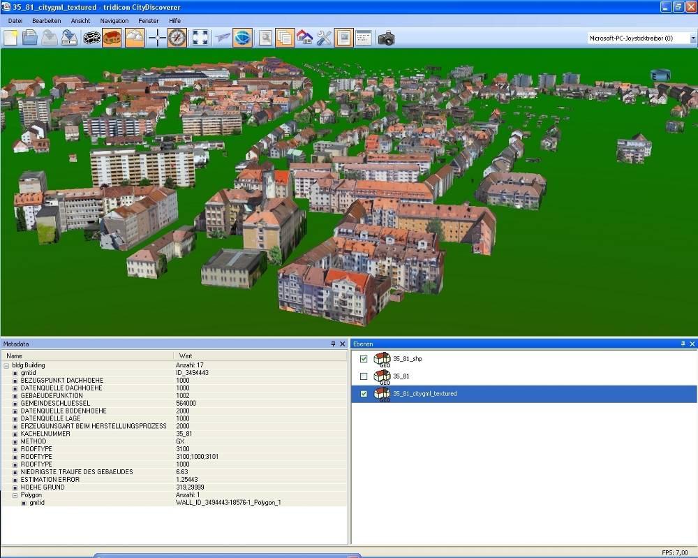
tridicon CityDiscoverer
The new generation of the cutting edge 3D analysis software tridicon® CityDiscoverer combines the virtues of the current CityDiscoverer with a completely new user experience and more intuitive handling. Combining 2D and 3D data from different sources, visualizing and analysing them in a joint project becomes just as easy as putting together an office presentation.
To achieve this goal, the development team of GTA Geoinformatik GmbH has added an extended support for 3D geometry format conversion ( import and export of CityGML, OBJ, VRML, SHAPE, KMZ, DXF, ...) as well as for instance import of Open Street Map geometry, support for web services and more.
Still tridicon® CityDiscoverer comes along as a rather lightweight application with focus on high performance visualization of an unlimited number of buildings and very large areas of hundreds of km². GTA's advanced streaming technology enables the visualization of large scale urban 3D environments without having to install a database or the need for sophisticated hardware.
3D analysis functionality like line of sight or shadow analysis, video generation and much more round off the experience as the perfect tool for urban planning, urban 3D visualization and the use of 3D city models in general. The free light version for a quick view on 3D data and for distributing visualization projects will be available at http://www.tridicon.de starting from INTERGEO 2011.
GTA Geoinformatik GmbH will present its full range of new pathbreaking software solutions for automatic creation and utilization of 3D city models 2011 at Nuremberg from the 27th to the 29th of September (Hall 7A, booth G45).
About GTA Geoinformatik GmbH
GTA, founded in 1991 as geoinformatics company with its main office in Neubrandenburg, Germany, is one of the leading developers and producers in 3D city modelling technology worldwide. Main product is the software suite tridiconTM 3D which was developed over the last ten years, containing the automatic generation of 3D city models as well as automatic texturing tools and different solutions for the generation of almost any level of detail of a 3D city model.
GTA Geoinformatik GmbH also licenses out more than 200 digital 3D city maps for European and North American capitals and major cities.
GTA Geoinformatik GmbH
Managing director: Dr. Peter Lieckfeldt
Lindenstraße 63, D-17033 Neubrandenburg
Tel: +49 395 3581 142
Fax: +49 395 3684 424
Email: contact@tridicon.de
Internet: www.tridicon.de
Marketing contact: Kathrin Hutton
hutton@gta-geo.de, Tel +49 395 3581 238
This release was published on openPR.
Permanent link to this press release:
Copy
Please set a link in the press area of your homepage to this press release on openPR. openPR disclaims liability for any content contained in this release.
You can edit or delete your press release New Generation of tridicon® CityDiscoverer Released here
News-ID: 192972 • Views: …
More Releases from GTA Geoinformatik GmbH
New Software Solution for Automatic Point Cloud Generation and 3D Modelling from …
GTA Geoinformatik GmbH presents new 3D software solutions at COM.GEO 2012 in Washington D.C.
Fully automated generation of very dense 3D point clouds and Digital Surface Models (DSM) from stereo aerial images (nadir and oblique) seems to become more and more important. Most efficiently this is done using semi global matching (SGM) algorithms. With the software release tridicon® PointCloud GTA offers a new tool that produces accurate point clouds for…

Breakthrough in Automatic Analysis of Aerial Images with Computer Stereo Vision
GTA Geoinformatik GmbH presents revolutionary new technology for automatic 3D object reconstruction without help of any 2D map data at CeBIT 2012
At this years CeBIT in Hannover dated 06th to 10th March GTA for the first time presents a prototype of a new tridicon® software version, that enables the detection of 3D objects like buildings without the need for 2D vector data (e. g. building outlines). The only source…
New Possibilities in Digitizing Aerial Images - Enhance Safety and Usability of …
Most larger municipalities or government agencies as well as many privately owned companies from the geodata sector own a large archive of aerial imagery on film. These archives contain a value of many ten thousands of dollars which is hardly used or recognized. Today's scanning technology together with up to date software tools and data storage systems make possible a much higher scanning resolution than only few years ago. Where…
High-Quality 3D Modelling Using Georeferenced Photography
Production of georeferenced digital 3D landmarks from terrestrial photography using the software suite tridicon® 3D LANDMARK
Digital 3D city models become very popular. Internet maps and car navigation are much more user-friendly when using 3D visualisation. Many municipalities use 3D city models for applications in town and environmental planning, for noise control management, for solar panel assessments or for marketing purposes. New technologies like 3D printing allow the fast and cost-efficient…
More Releases for City
Smart City & Connected City Solutions Market 2021 | Detailed Report
The Smart City & Connected City Solutions market research report undoubtedly meets the strategic and specific needs of the businesses and companies. The report acts as a perfect window that provides an explanation of market classification, market definition, applications, market trends, and engagement. The competitive landscape is studied here in terms of product range, strategies, and prospects of the market’s key players. Furthermore, the report offers insightful market data and…
Global Smart City & Connected City Solutions Market Status and Outlook (2020-202 …
Global Info Research offers a latest published report on Smart City & Connected City Solutions Analysis and Forecast 2020-2025 delivering key insights and providing a competitive advantage to clients through a detailed report. This report focuses on the key global Smart City & Connected City Solutions Concentrate players, to define, describe and analyze the value, market share, market competition landscape, SWOT analysis and development plans in next few years.
Click to…
Food for the city - from the city
Fraunhofer IAO publishes study on urban farming
Whereas the number of people living in cities worldwide is continually growing, the already scarce area used for growing food and resources has been steadily shrinking. This disparity, however, can be partly bridged by urban farming, the practice of growing food in cities and urban areas. Fraunhofer IAO has published a study investigating how cities could benefit from locally grown food and resources, looking…
The City of Milwaukee Gets A New Mobile City Guide App
Get Up. Get Out. Explore!
Milwaukee's First City Guide for Tourists, Residents & Businesses
Over the Memorial Day Weekend Get Up Milwaukee proudly announces the emergence of the first ever friendliest local guide app for the City of Milwaukee. The hot new local application comes in handy with all features being user-friendly for finding daily activities and local business information.
Get Up Milwaukee is the first app of its kind catered towards the…
New York City flats – New York City Accommodation
We are glad to announce our new website new-york-city-apartments.net which provides top rated accommodation and services at lowest price for tourists visiting New York. New York is a famous city in United State of America, known for its financial, cultural, transportation, and manufacturing center. There are millions of people currently located in New York, in spite of this there are lots more visiting New York daily due to business trip…
Luxor city portal - first official city portal in Egypt
(31 March, 2009) – Tourists anywhere in the world who wish to find out more about Luxor before their visit to this city of wonders can now avail of a wide range of online services and information with the launch of the Luxor portal, developed and designed by LINK Development in association with Microsoft Egypt.
The first official city portal in Egypt (luxoregypt.org) which was inaugurated during an official visit by…