Press release
Honduras Aerial Surveys
The project called Catastro de Cortés is a free public service provided by the Instituto de la Propiedad (IP) through the Programa de Administración de Tierras de Honduras (PATH). It deals mainly with cartographic activities and cadastral information of 5 municipalities in the state of Cortés: San Pedro Sula, Puerto Cortés, Choloma, Villanueva, and La Lima. In this project, GeoAir was responsible for taking some 4,600 digital aerial photographs covering more than 3,500 sq km and helped in the survey of more than 245,000 properties.
For more detailed information about this program please visit: http://www.catastrodecortes.com/
GeoAir flew to Honduras and took part in an EU-sponsored project which includes cadastre, land management and park protection.
This project was done thanks to a partnership between the Republic of Honduras and the European Union. It’s goal was to support and evaluate landholdings, to facilitate multifunctional cadastre information and to assure landowners of their property rights. This would generate some additional property tax income for the Government of Honduras as well as protect the boundaries of the Pico Bonito National Park.
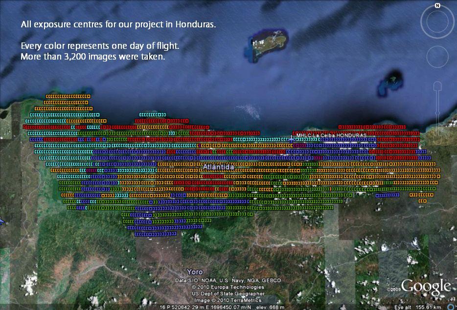
Due to its vast experience, excellent commitment to its projects, and high standards, GeoAir was chosen as the aerial survey company to deliver high resolution digital imagery of the entire state of Atlantida in Honduras on February, 2010. After a first unsuccessful attempt in May 2009 because of adverse weather conditions, one year later GeoAir was able to take more than 3,200 high resolution images in a record time of only 5 days of flying.
GeoAir proporciona todas las imágenes digitales aéreas para el catastro del departamento de Cortés en Honduras
El Proyecto Catastro de Cortés es un servicio gratuito impulsado por el Instituto de la Propiedad (IP), a través del Programa de Administración de Tierras de Honduras (PATH). Consiste en la realización de actividades cartográficas y levantamiento catastral en cinco (5) municipios del Departamento de Cortés: San Pedro Sula, Puerto Cortés, Choloma, Villanueva y La Lima. En esta ocasión GeoAir fue responsable de fotografiar más de 3,500 km2 que ayudarán a la medición de aproximadamente 245,000 predios. Todo esto representado en casi 4,600 imágenes digitales de alta calidad.
Para mayor información visita: http://www.catastrodecortes.com/
GeoAir participa en Honduras de un proyecto ecológico patrocinado por la Unión Europea
Este proyecto para la preservación de recursos naturales es una iniciativa de cooperación de la República de Honduras con la Comisión Europea y tiene como objetivo facilitar la realización de un catastro multifuncional que garantice la tenencia de tierra, disminuyendo así la vulnerabilidad de las áreas protegidas y parques nacionales.
Gracias a su vasta experiencia y excelente calidad y compromiso, GeoAir fue seleccionada para suministrar imágenes aéreas digitales de alta resolución de todo el departamento de Atlántida, Honduras. A pesar de que la zona es difícil de volar debido a que incluye un bosque nublado de montaña, humedales y playas costeras, y después de un intento fallido durante el año anterior, finalmente se lograron tomar más de 3,200 fotografías de excelente calidad en un tiempo récord de 5 días.
GeoAir is a Mexican company offering a FULL RANGE OF AERIAL SURVEYS
We operate aircraft with the most advanced data capture technology nowadays on the market, supported by many years of international experience of its owners and employees.
Although the foundation of GeoAir S.A. de C.V. took only place in 1995 we have been flying successfully thousands of square kilometres in 30 countries with all different kinds of films. Among other companies we have been flying for such renowned companies like Hansa Luftbild of Germany, Swissphoto of Switzerland, Orthoshop, GeoMapa, Cartodata, SAP and Horizons in Mexico, ISTAR of France, GeoSurv, Eaglemapping and DTM of Canada, Geocart, Stereocarto and Azimut in Spain, the United Nations and many other institutions and ministries.
GeoAir es una empresa altamente especializada en la elaboración de vuelos fotográficos de medición. Contamos con la tecnología más moderna en esta área, con personal altamente calificado y con muchos años de experiencia.
Operamos aeronaves provistos con los mejores equipos de fotografía aérea que existen actualmente, apoyados por la tecnología más avanzada para lograr una navegación aérea de alta precisión, apoyada por satélite.
Aunque fundada apenas en el año de 1995, nuestro personal cuenta con experiencia de más de veinte años en esta área. La precisión y alta calidad de nuestros trabajos han satisfecho las exigencias de empresas mexicanas y extranjeras (europeas y norte americanas). Hemos trabajado para las empresas más grandes de fotogrametría, tales como Hansa Luftbild en Alemania, Swissphoto de Suiza, Orthoshop, GeoMapa, Cartodata, SAP y Horizons México, GeoSurv, Eaglemapping y DTM en Canadá, ISTAR en Francia, Geocart, Stereocarto y Azimut en España, las Naciones Unidas y otras instituciones.
GeoAir S.A. de C.V.
Avenida Alfanjes 1
Izcalli Acatitlán
Tlalnepantla
Estado de México
C.P. 54140 / MÈXICO
Tel: +52-777-361-3875
info @ geoair.net
info @ geoair-internacional.com
This release was published on openPR.
Permanent link to this press release:
Copy
Please set a link in the press area of your homepage to this press release on openPR. openPR disclaims liability for any content contained in this release.
You can edit or delete your press release Honduras Aerial Surveys here
News-ID: 141542 • Views: …
More Releases from GeoAir Internacional

Aerial Survey Flight for Mexico City Cadaster
In only four weeks time GeoAir managed to fly the whole Mexico City Cadaster project. It is the first digital camera flight of such dimensions in Latin America.
The flight was executed with a Microsoft/Vexcel large format UltraCam digital aerial camera using IMU and airborne DGPS. A total of more than 9,000 images were taken also on Christmas Day. The postprocess of all images was done in the offices of GeoAir.…
More Releases for Honduras
Honduras Tourism: Hotel Sandoval 40 Years in Business
Nueva Ocotepeque, Honduras (Date Published) not submitted
Although tourism is impacted globally, Hotel Sandoval operating in the western part of Honduras lives and breathes comfort, tranquility and tourism.
Whether you are looking to visit the south of Honduras for business and/or adventure, Hotel Sandoval has you covered. Their spacious rooms, restaurant, and pool area offer the best of both worlds. The restaurant on-site, open-air pool area and patio, and fast WiFI…
Honduras Global Key Players - Tigo Honduras, Claro Honduras, Hondutel, and Multi …
Honduras
Overview
"Honduras: Country Intelligence Report", a new Country Intelligence Report provides an executive-level overview of the telecommunications market in Honduras today, with detailed forecasts of key indicators up to 2022. Published annually, the report provides detailed analysis of the near-term opportunities, competitive dynamics and evolution of demand by service type and technology/platform across the fixed telephony, broadband, mobile and pay-TV segments, as well as a review of key regulatory trends.
Honduras’ telecom…
Honduras Upcoming 3G and 4G Spectrum Allocations Competition Market Report 2017
Market Research Hub (MRH) has recently announced the addition of a fresh report, titled “Honduras: Upcoming 3G and 4G Spectrum Allocations to Attract New Player and Drive Mobile Competition” to its report offerings. The report provides detailed analysis of the near-term opportunities, competitive dynamics and evolution of demand by service type and technology/platform across the fixed telephony, broadband, mobile and pay-TV sectors, as well as a review of key regulatory…
Online Honduras TV
This Online Honduras TV is made by the experts who tend to meet the needs of our users. The innovative TV application empowers you to watch local, as well as the International TV channels and additionally listen to live Radio streams. This application is composed just for iOS gadget and serves diverse TV program, motion pictures, news, music and additionally YouTube recordings etc.
This Honduras TV application, designed for iPad,…
Fantasy Island Resort in Roatan Honduras Sure to Please
Roatan, Honduras – December 15th , 2009 - Located on picturesque Honduras Roatan is one of the most sought after resort locations for vacationers from all over the world. The 30 mile long island has become a favourite for travelers for its serene Caribbean landscapes and warm tropical breezes. Surrounded by bright white sandy beaches and crystal clear waters the Fantasy Island Beach Resort by Privilege Hotels sits majestically amidst…
Government of Honduras Accelerates Activation of Aidmatrix Network™
COPECO Honduras and the First Lady's Office - Government of Honduras Now Linked-In
The Aidmatrix Foundation, a nonprofit using supply-chain technology to create an exchange network for humanitarian aid and disaster relief, announces the Republic of Honduras has formally joined the network for Hurricane Felix Relief as well as ongoing relief efforts and donations management.
Dallas, TX, September 7, 2007 -- The Aidmatrix Foundation® (Aidmatrix) today announced the Republic of Honduras'…